IMAGES TAKEN NEAR TO
Parkwood Street, KEIGHLEY, BD21 4PJ
Introduction
This page details the photographs taken nearby to Parkwood Street, BD21 4PJ by members of the Geograph project.
The Geograph project started in 2005 with the aim of publishing, organising and preserving representative images for every square kilometre of Great Britain, Ireland and the Isle of Man.

There are currently over 7.5m images from over14,400 individuals and you can help contribute to the project by visiting https://www.geograph.org.uk
Image Map (Loading...)


Getting Data...Please wait
Leaflet Map data © OpenStreetMap
Images are licensed for reuse under creativecommons.org/licenses/by-sa/2.0
Notes
- Clicking on the map will re-center to the selected point.
- The higher the marker number, the further away the image location is from the centre of the postcode.
Image Listing (256 Images Found)
Images are licensed for reuse under creativecommons.org/licenses/by-sa/2.0
Image
Details
Distance
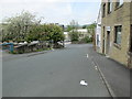
1
Pitt Street - looking towards Low Mill Lane
Image: © Betty Longbottom
Taken: 3 May 2014
0.07 miles
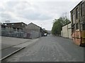
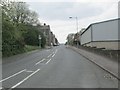
2
Parkwood Street - viewed from Grace Street
Image: © Betty Longbottom
Taken: 3 May 2014
0.08 miles
5
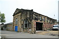
Strong Close Ironworks, Keighley
This was one of several factories operated by Messrs Prince Smith, later Prince Smith Stells. They were primarily textile machinery manufacturers and this ironworks was built on a greenfield site in about 1912.
The view shows two buildings that look like engine houses side by side. My contact Geoff Shackleton tells me that the company bought a horizontal tandem compound engine from Cole, Marchent and Morley of Bradford in 1910 for Strong Close Ironworks. In 1924 the same maker supplied a uniflow engine with a 31" x 30" cylinder driving a 500 kW, 230 V DC generator. It is not stated whether the later engine replaced the earlier one or supplemented it. I suspect the latter.
Image: © Chris Allen
Taken: 21 Apr 2007
0.10 miles
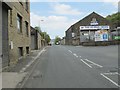
6
Parkwood Street - viewed from Grace Street
Image: © Betty Longbottom
Taken: 3 May 2014
0.11 miles
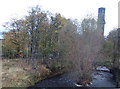
8
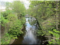
River Worth - viewed from off Pitt Street
Image: © Betty Longbottom
Taken: 3 May 2014
0.11 miles
9
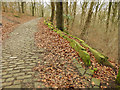
Footpath to Thwaites Brow (4)
A splendid example of a stone-setted footpath from the days of the Industrial Revolution, which appears on maps as early as 1852. I presume it was for workers to reach the factories in the town of Keighley (and at another time maybe for quarry workers living in the valley bottom to reach the quarries higher up the hill).
This view in Park Wood shows how the path has tended to slip down the hillside, despite repeated attempts to stop it with stone flags.
Image: © Stephen Craven
Taken: 13 Jan 2018
0.11 miles
10

Foundry Wall near Dalton Mills
This was across the river, photographed from Dalton Mills
Image: © Alan Longbottom
Taken: 26 Oct 2007
0.12 miles