IMAGES TAKEN NEAR TO
The Orchard, KEIGHLEY, BD21 4NT
Introduction
This page details the photographs taken nearby to The Orchard, BD21 4NT by members of the Geograph project.
The Geograph project started in 2005 with the aim of publishing, organising and preserving representative images for every square kilometre of Great Britain, Ireland and the Isle of Man.

There are currently over 7.5m images from over14,400 individuals and you can help contribute to the project by visiting https://www.geograph.org.uk
Image Map (Loading...)


Getting Data...Please wait
Leaflet Map data © OpenStreetMap
Images are licensed for reuse under creativecommons.org/licenses/by-sa/2.0
Notes
- Clicking on the map will re-center to the selected point.
- The higher the marker number, the further away the image location is from the centre of the postcode.
Image Listing (42 Images Found)
Images are licensed for reuse under creativecommons.org/licenses/by-sa/2.0
Image
Details
Distance
1

Bracewell Street - Parkwood Street
Image: © Betty Longbottom
Taken: 15 Jan 2014
0.04 miles
2

Bracewell Street - Elizabeth Street
Image: © Betty Longbottom
Taken: 15 Jan 2014
0.05 miles
3
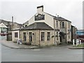
Shoulder of Mutton - Parkwood Street
Image: © Betty Longbottom
Taken: 15 Jan 2014
0.05 miles
4

Parkwood Street - viewed from Primrose Street
Image: © Betty Longbottom
Taken: 15 Jan 2014
0.05 miles

6

Elizabeth Street - Primrose Street
Image: © Betty Longbottom
Taken: 15 Jan 2014
0.05 miles
7

Parkwood Street - viewed from Primrose Street
Image: © Betty Longbottom
Taken: 15 Jan 2014
0.07 miles
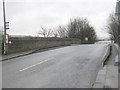
9
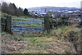
Field gate on west side of Thwaites Brow Road
There is an OS benchmark Image on the left hand gatepost
Image: © Roger Templeman
Taken: 15 Feb 2018
0.07 miles
10
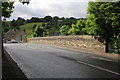
Thwaites railway bridge
There is an OS benchmark Image near the right end of the far parapet
Image: © Roger Templeman
Taken: 29 Jun 2012
0.07 miles