IMAGES TAKEN NEAR TO
Aire Valley Road, KEIGHLEY, BD21 4LU
Introduction
This page details the photographs taken nearby to Aire Valley Road, BD21 4LU by members of the Geograph project.
The Geograph project started in 2005 with the aim of publishing, organising and preserving representative images for every square kilometre of Great Britain, Ireland and the Isle of Man.

There are currently over 7.5m images from over14,400 individuals and you can help contribute to the project by visiting https://www.geograph.org.uk
Image Map (5 Images)


Getting Data...Please wait
Leaflet Map data © OpenStreetMap
Images are licensed for reuse under creativecommons.org/licenses/by-sa/2.0
Notes
- Clicking on the map will re-center to the selected point.
- The higher the marker number, the further away the image location is from the centre of the postcode.
Image Listing (5 Images Found)
Images are licensed for reuse under creativecommons.org/licenses/by-sa/2.0
Image
Details
Distance
1
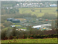
Marley sewage treatment works
A large sewage works on the River Aire, processing domestic and industrial waste water from the Keighley area, viewed from the hillside to the west.
Image: © Stephen Craven
Taken: 13 Jan 2018
0.04 miles
2
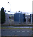
Airevalley Road (A650)
Water treatment works silos behind.
Image: © JThomas
Taken: 3 Nov 2012
0.11 miles
5

River Aire near East Riddlesden Hall
View looking downstream from the "Riverside Walk" in the National Trust grounds near East Riddlesden Hall.
Image: © David Dixon
Taken: 1 Jun 2013
0.22 miles