IMAGES TAKEN NEAR TO
Wardman Street, KEIGHLEY, BD21 4AN
Introduction
This page details the photographs taken nearby to Wardman Street, BD21 4AN by members of the Geograph project.
The Geograph project started in 2005 with the aim of publishing, organising and preserving representative images for every square kilometre of Great Britain, Ireland and the Isle of Man.

There are currently over 7.5m images from over14,400 individuals and you can help contribute to the project by visiting https://www.geograph.org.uk
Image Map
Images are licensed for reuse under creativecommons.org/licenses/by-sa/2.0
Notes
- Clicking on the map will re-center to the selected point.
- The higher the marker number, the further away the image location is from the centre of the postcode.
Image Listing (106 Images Found)
Images are licensed for reuse under creativecommons.org/licenses/by-sa/2.0
Image
Details
Distance

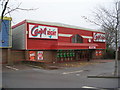
4
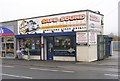
Safe & Sound Car Technology - Bradford Road
Image: © Betty Longbottom
Taken: 6 Feb 2010
0.02 miles
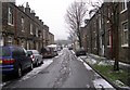
6
Vale Street - Bradford Road, Keighley
Image: © Betty Longbottom
Taken: 15 Oct 2008
0.02 miles
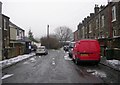
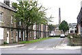
7
Bradford Road, Aireworth
The original main road going down the valley of the River Aire.
Image: © Bill Boaden
Taken: 9 Jun 2023
0.03 miles
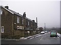
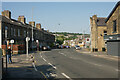
8
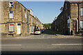
Craven Road, Aireworth
One of a series of parallel terraced streets running off Bradford Road.
Image: © Bill Boaden
Taken: 9 Jun 2023
0.03 miles