IMAGES TAKEN NEAR TO
Eric Street, KEIGHLEY, BD21 3LS
Introduction
This page details the photographs taken nearby to Eric Street, BD21 3LS by members of the Geograph project.
The Geograph project started in 2005 with the aim of publishing, organising and preserving representative images for every square kilometre of Great Britain, Ireland and the Isle of Man.

There are currently over 7.5m images from over14,400 individuals and you can help contribute to the project by visiting https://www.geograph.org.uk
Image Map
Images are licensed for reuse under creativecommons.org/licenses/by-sa/2.0
Notes
- Clicking on the map will re-center to the selected point.
- The higher the marker number, the further away the image location is from the centre of the postcode.
Image Listing (113 Images Found)
Images are licensed for reuse under creativecommons.org/licenses/by-sa/2.0
Image
Details
Distance
1
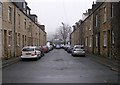
Rupert Street - from Lawkholme Lane, Keighley
Image: © Betty Longbottom
Taken: 15 Oct 2008
0.01 miles

3
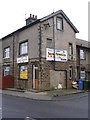
Azeem's Accessories - Lawkholme Lane
Image: © Betty Longbottom
Taken: 6 Feb 2010
0.02 miles
6
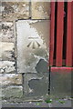
Benchmark on #132 Lawkholme Lane
Ordnance Survey cut mark benchmark described on the Bench Mark Database at http://www.bench-marks.org.uk/bm43886
Image: © Roger Templeman
Taken: 29 Jun 2012
0.03 miles
7
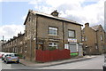
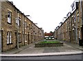
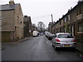
#132 Lawkholme Lane at junction with Eric Street
There is an OS benchmark Image on the corner of the house at the junction with the wooden fence
Image: © Roger Templeman
Taken: 29 Jun 2012
0.03 miles