IMAGES TAKEN NEAR TO
High Street, KEIGHLEY, BD21 2LJ
Introduction
This page details the photographs taken nearby to High Street, BD21 2LJ by members of the Geograph project.
The Geograph project started in 2005 with the aim of publishing, organising and preserving representative images for every square kilometre of Great Britain, Ireland and the Isle of Man.

There are currently over 7.5m images from over14,400 individuals and you can help contribute to the project by visiting https://www.geograph.org.uk
Image Map
Images are licensed for reuse under creativecommons.org/licenses/by-sa/2.0
Notes
- Clicking on the map will re-center to the selected point.
- The higher the marker number, the further away the image location is from the centre of the postcode.
Image Listing (391 Images Found)
Images are licensed for reuse under creativecommons.org/licenses/by-sa/2.0
Image
Details
Distance
2
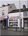
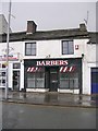
Amaans Restaurant & Takeaway - High Street
Image: © Betty Longbottom
Taken: 2 Feb 2010
0.01 miles
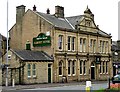

8

Keighley Town Centre
Viewed at the junction of High Street and Bridge Street.
Image: © Mary and Angus Hogg
Taken: 20 Apr 2012
0.03 miles
9
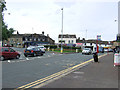
Keighley - A629/B6143 roundabout
Two main routes from the S/SW - the A629 from Halifax and the B6143 from Oakworth (left in this picture) - converge here, near the town centre.
Image: © David Ward
Taken: 25 Jul 2007
0.03 miles
10
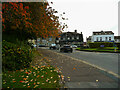
The west side of the Bridge Street and Oakworth Road roundabout
Image: © Humphrey Bolton
Taken: 22 Oct 2020
0.03 miles