IMAGES TAKEN NEAR TO
Merlin Court, KEIGHLEY, BD21 1SP
Introduction
This page details the photographs taken nearby to Merlin Court, BD21 1SP by members of the Geograph project.
The Geograph project started in 2005 with the aim of publishing, organising and preserving representative images for every square kilometre of Great Britain, Ireland and the Isle of Man.

There are currently over 7.5m images from over14,400 individuals and you can help contribute to the project by visiting https://www.geograph.org.uk
Image Map
Images are licensed for reuse under creativecommons.org/licenses/by-sa/2.0
Notes
- Clicking on the map will re-center to the selected point.
- The higher the marker number, the further away the image location is from the centre of the postcode.
Image Listing (155 Images Found)
Images are licensed for reuse under creativecommons.org/licenses/by-sa/2.0
Image
Details
Distance
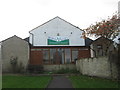
4
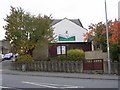
Worth Valley Community Church - South Street
This is a former school.
Image: © Betty Longbottom
Taken: 31 Oct 2007
0.04 miles
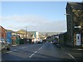
6
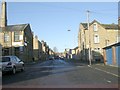
Victoria Road - viewed from Queen's Road
Image: © Betty Longbottom
Taken: 5 Jan 2009
0.04 miles
7

Elizabeth II Postbox, Catherine Street
Set into a wall at the junction with South Street
Image: © Mark Anderson
Taken: 5 Nov 2008
0.05 miles
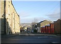
9
Berry Lane - viewed from Kensington Street
Image: © Betty Longbottom
Taken: 5 Jan 2009
0.06 miles
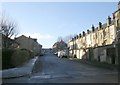
10
Queen's Road - viewed from Victoria Road
Image: © Betty Longbottom
Taken: 5 Jan 2009
0.06 miles