IMAGES TAKEN NEAR TO
Victoria Road, KEIGHLEY, BD21 1JP
Introduction
This page details the photographs taken nearby to Victoria Road, BD21 1JP by members of the Geograph project.
The Geograph project started in 2005 with the aim of publishing, organising and preserving representative images for every square kilometre of Great Britain, Ireland and the Isle of Man.

There are currently over 7.5m images from over14,400 individuals and you can help contribute to the project by visiting https://www.geograph.org.uk
Image Map
Images are licensed for reuse under creativecommons.org/licenses/by-sa/2.0
Notes
- Clicking on the map will re-center to the selected point.
- The higher the marker number, the further away the image location is from the centre of the postcode.
Image Listing (164 Images Found)
Images are licensed for reuse under creativecommons.org/licenses/by-sa/2.0
Image
Details
Distance
2
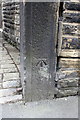
Benchmark on gatepost at entrance to #187 Oakworth Road
Ordnance Survey cut mark benchmark described on the Bench Mark Database at http://www.bench-marks.org.uk/bm44545
Image: © Roger Templeman
Taken: 11 Aug 2012
0.02 miles
3
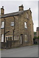
House on Oakworth Road
There is an OS benchmark Image on the gatepost near the left hand side of the image.
Image: © Roger Templeman
Taken: 11 Aug 2012
0.02 miles

7
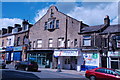
Exley Head Cinema.
Keighley, Oakworth Road.
Image: © Andrew Riley
Taken: 3 Aug 2013
0.02 miles

9

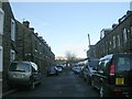
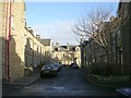
Back Rydal Street - Cross Rydal Street
Image: © Betty Longbottom
Taken: 5 Jan 2009
0.03 miles
