IMAGES TAKEN NEAR TO
Bran Street, KEIGHLEY, BD21 1BX
Introduction
This page details the photographs taken nearby to Bran Street, BD21 1BX by members of the Geograph project.
The Geograph project started in 2005 with the aim of publishing, organising and preserving representative images for every square kilometre of Great Britain, Ireland and the Isle of Man.

There are currently over 7.5m images from over14,400 individuals and you can help contribute to the project by visiting https://www.geograph.org.uk
Image Map (Loading...)


Getting Data...Please wait
Leaflet Map data © OpenStreetMap
Images are licensed for reuse under creativecommons.org/licenses/by-sa/2.0
Notes
- Clicking on the map will re-center to the selected point.
- The higher the marker number, the further away the image location is from the centre of the postcode.
Image Listing (255 Images Found)
Images are licensed for reuse under creativecommons.org/licenses/by-sa/2.0
Image
Details
Distance


8

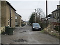
Works building, Ingrow Lane
There is an OS benchmark Image on the near corner of the building
Image: © Roger Templeman
Taken: 15 May 2015
0.03 miles
10
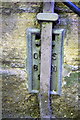
Benchmark (behind lightning conductor) on Ingrow Lane factory
Ordnance Survey flush bracket (serial number 976) benchmark described on the Bench Mark Database at https://www.bench-marks.org.uk/bm9870
Image: © Roger Templeman
Taken: 15 May 2015
0.04 miles