IMAGES TAKEN NEAR TO
Dene Grove, KEIGHLEY, BD20 9NR
Introduction
This page details the photographs taken nearby to Dene Grove, BD20 9NR by members of the Geograph project.
The Geograph project started in 2005 with the aim of publishing, organising and preserving representative images for every square kilometre of Great Britain, Ireland and the Isle of Man.

There are currently over 7.5m images from over14,400 individuals and you can help contribute to the project by visiting https://www.geograph.org.uk
Image Map (Loading...)


Getting Data...Please wait
Leaflet Map data © OpenStreetMap
Images are licensed for reuse under creativecommons.org/licenses/by-sa/2.0
Notes
- Clicking on the map will re-center to the selected point.
- The higher the marker number, the further away the image location is from the centre of the postcode.
Image Listing (95 Images Found)
Images are licensed for reuse under creativecommons.org/licenses/by-sa/2.0
Image
Details
Distance
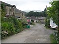
1
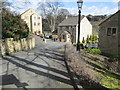
Hunters Glen - viewed from East Dene
Image: © Betty Longbottom
Taken: 24 Mar 2015
0.02 miles
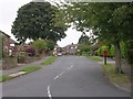
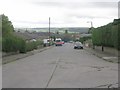
4
Sackville Road - viewed from North Dene Road
Image: © Betty Longbottom
Taken: 29 Sep 2009
0.07 miles
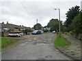
5
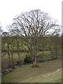
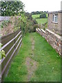
Tree at SE043470, Silsden
A magnificent tree on the flat area beside Great Gill Beck, looking down from the footpath that climbs to Town Head.
Image: © Humphrey Bolton
Taken: 19 Mar 2006
0.07 miles
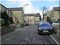
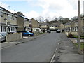
10
Hillcrest Avenue - viewed from Sackville Road
Image: © Betty Longbottom
Taken: 24 Mar 2015
0.12 miles