IMAGES TAKEN NEAR TO
Ridge Lane, KEIGHLEY, BD20 9JQ
Introduction
This page details the photographs taken nearby to Ridge Lane, BD20 9JQ by members of the Geograph project.
The Geograph project started in 2005 with the aim of publishing, organising and preserving representative images for every square kilometre of Great Britain, Ireland and the Isle of Man.

There are currently over 7.5m images from over14,400 individuals and you can help contribute to the project by visiting https://www.geograph.org.uk
Image Map (Loading...)


Getting Data...Please wait
Leaflet Map data © OpenStreetMap
Images are licensed for reuse under creativecommons.org/licenses/by-sa/2.0
Notes
- Clicking on the map will re-center to the selected point.
- The higher the marker number, the further away the image location is from the centre of the postcode.
Image Listing (7 Images Found)
Images are licensed for reuse under creativecommons.org/licenses/by-sa/2.0
Image
Details
Distance
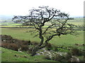
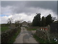
3
High Edge.
Just on the edge of Skipton Moor access land. Looking W.
Image: © Steve Partridge
Taken: 16 Apr 2006
0.06 miles
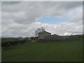
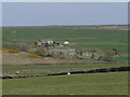
5
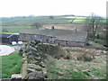
Low Edge Farm.
Right near the top edge of the square.
Image: © Steve Partridge
Taken: 16 Apr 2006
0.12 miles
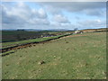
6
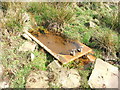
Sunken bath.
Probably placed here originally as a source of water for livestock. I doubt that sheep would know how to use the taps though. Near High Edge.
Image: © Steve Partridge
Taken: 16 Apr 2006
0.20 miles