IMAGES TAKEN NEAR TO
Kiln Hill Lane, KEIGHLEY, BD20 9HR
Introduction
This page details the photographs taken nearby to Kiln Hill Lane, BD20 9HR by members of the Geograph project.
The Geograph project started in 2005 with the aim of publishing, organising and preserving representative images for every square kilometre of Great Britain, Ireland and the Isle of Man.

There are currently over 7.5m images from over14,400 individuals and you can help contribute to the project by visiting https://www.geograph.org.uk
Image Map (Loading...)


Getting Data...Please wait
Leaflet Map data © OpenStreetMap
Images are licensed for reuse under creativecommons.org/licenses/by-sa/2.0
Notes
- Clicking on the map will re-center to the selected point.
- The higher the marker number, the further away the image location is from the centre of the postcode.
Image Listing (10 Images Found)
Images are licensed for reuse under creativecommons.org/licenses/by-sa/2.0
Image
Details
Distance
1
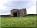
Cocklick Laithe
On Cocklick Hill. See also Image
Image: © David Spencer
Taken: 20 Jun 2007
0.00 miles
2
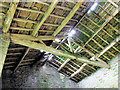
Roof detail, interior, Cocklick Laithe
The exterior view can be seen in Image
Image: © David Spencer
Taken: 20 Jun 2007
0.00 miles
3
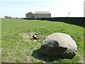
Dry spring on Cocklick Hill
It had been a very dry spring season.
The property in the background was formerly known as Cocklick Laithe. Image shows it in 2007 before it was converted and extended; it now has the rather pretentious name "The Hobbit".
Image: © Stephen Craven
Taken: 20 Apr 2019
0.04 miles
4
Cocklick Hill
viewed from Cocklick Laithe
Image: © David Spencer
Taken: 20 Jun 2007
0.07 miles
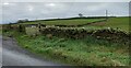
5
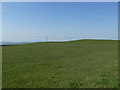
Cocklick Hill
Another contributor's photo Image shows a similar view in 2007 before the turbine appeared.
Image: © Stephen Craven
Taken: 20 Apr 2019
0.09 miles
6
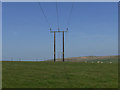
Power lines across the moor
Between Cocklick Hill and High Bracken Hill.
Image: © Stephen Craven
Taken: 20 Apr 2019
0.10 miles
7
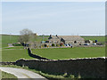
Smoulden Farm
From Wilcock Lane (public footpath).
Image: © Stephen Craven
Taken: 20 Apr 2019
0.22 miles
8
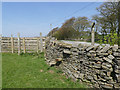
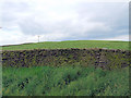
Stile onto Green Lane
The lane beyond the wall is the county boundary between North Yorkshire (Craven District) this side, and West Yorkshire (Bradford District) on the other.
Image: © Stephen Craven
Taken: 20 Apr 2019
0.23 miles
9
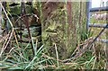
Low Bradley, Kiln Hill Lane
The benchmark is cut into a left hand gatepost of a gateway on the west side of the lane.
Image: © Mel Towler
Taken: 10 Nov 2021
0.24 miles
10
Low Bradley, Kiln Hill Lane
There is a benchmark cut into a left hand gatepost of the gateway on the west side of the lane.
Image: © Mel Towler
Taken: 10 Nov 2021
0.24 miles