IMAGES TAKEN NEAR TO
Haygill Nook, KEIGHLEY, BD20 9FB
Introduction
This page details the photographs taken nearby to Haygill Nook, BD20 9FB by members of the Geograph project.
The Geograph project started in 2005 with the aim of publishing, organising and preserving representative images for every square kilometre of Great Britain, Ireland and the Isle of Man.

There are currently over 7.5m images from over14,400 individuals and you can help contribute to the project by visiting https://www.geograph.org.uk
Image Map (Loading...)


Getting Data...Please wait
Leaflet Map data © OpenStreetMap
Images are licensed for reuse under creativecommons.org/licenses/by-sa/2.0
Notes
- Clicking on the map will re-center to the selected point.
- The higher the marker number, the further away the image location is from the centre of the postcode.
Image Listing (4 Images Found)
Images are licensed for reuse under creativecommons.org/licenses/by-sa/2.0
Image
Details
Distance
1

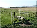
Stile on Snow Hill Allotment
The stile allows progress for the footpath between Back Allotment on the Skipton Old Road (now a track) to Snow Hill Farm and Carr Bog Farm.
Image: © Chris Heaton
Taken: 20 Apr 2011
0.19 miles
2

Stile the watershed, Skipton
As you reach this stile a view of Wharfedale in the far distance, and then the valley of Haw Beck, opens up.
Image: © Humphrey Bolton
Taken: 10 Apr 2011
0.19 miles
3
Stile onto Snow Hill Allotment, Skipton
Image: © Humphrey Bolton
Taken: 10 Apr 2011
0.22 miles
4

Spring Lamb near Haygill Farm.
Now where's that jar of mint sauce...............
Image: © Steve Partridge
Taken: 16 Apr 2006
0.23 miles