IMAGES TAKEN NEAR TO
Matthew Lane, KEIGHLEY, BD20 9DF
Introduction
This page details the photographs taken nearby to Matthew Lane, BD20 9DF by members of the Geograph project.
The Geograph project started in 2005 with the aim of publishing, organising and preserving representative images for every square kilometre of Great Britain, Ireland and the Isle of Man.

There are currently over 7.5m images from over14,400 individuals and you can help contribute to the project by visiting https://www.geograph.org.uk
Image Map
Images are licensed for reuse under creativecommons.org/licenses/by-sa/2.0
Notes
- Clicking on the map will re-center to the selected point.
- The higher the marker number, the further away the image location is from the centre of the postcode.
Image Listing (133 Images Found)
Images are licensed for reuse under creativecommons.org/licenses/by-sa/2.0
Image
Details
Distance


4
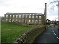
Cross Lane Mill
Built around 1864 in a field away from the town centre.
Image: © Chris Heaton
Taken: 30 Jan 2008
0.04 miles
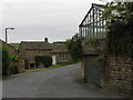
5
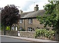
Box Tree Farm, Low Bradley
Late 18th century building [now two houses] in local stone with attractive sandstone lintels and quoins.
Image: © Gordon Hatton
Taken: 13 Jul 2009
0.05 miles
6
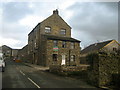
Rose Terrace, Low Bradley
Built around 1870 to provide housing for mill workers.
Image: © Chris Heaton
Taken: 30 Jan 2008
0.05 miles
8
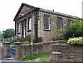
Bradley Methodist Church
Bradley Methodist Church at the top of Ings Lane.
Image: © David Rogers
Taken: 9 Jul 2008
0.06 miles
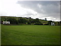
10
Crag Lane Bottom
View of Crag Lane Bottom at Low Bradley.
Image: © David Rogers
Taken: 9 Jul 2008
0.07 miles