IMAGES TAKEN NEAR TO
Starkey Lane, KEIGHLEY, BD20 9AN
Introduction
This page details the photographs taken nearby to Starkey Lane, BD20 9AN by members of the Geograph project.
The Geograph project started in 2005 with the aim of publishing, organising and preserving representative images for every square kilometre of Great Britain, Ireland and the Isle of Man.

There are currently over 7.5m images from over14,400 individuals and you can help contribute to the project by visiting https://www.geograph.org.uk
Image Map (Loading...)


Getting Data...Please wait
Leaflet Map data © OpenStreetMap
Images are licensed for reuse under creativecommons.org/licenses/by-sa/2.0
Notes
- Clicking on the map will re-center to the selected point.
- The higher the marker number, the further away the image location is from the centre of the postcode.
Image Listing (237 Images Found)
Images are licensed for reuse under creativecommons.org/licenses/by-sa/2.0
Image
Details
Distance


7
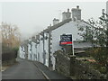
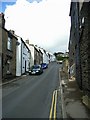
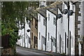
Terraced houses on Starkey Lane, Kildwick
Shown on the large-scale OS map surveyed in 1889, but not listed buildings.
Image: © Christine Johnstone
Taken: 29 Nov 2022
0.06 miles


10
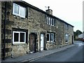
Cottages and Shop,late c17, Newby Road, Farnhill
Image: © Stanley Walker
Taken: 6 Oct 2010
0.08 miles