IMAGES TAKEN NEAR TO
Ryecroft Way, KEIGHLEY, BD20 8PT
Introduction
This page details the photographs taken nearby to Ryecroft Way, BD20 8PT by members of the Geograph project.
The Geograph project started in 2005 with the aim of publishing, organising and preserving representative images for every square kilometre of Great Britain, Ireland and the Isle of Man.

There are currently over 7.5m images from over14,400 individuals and you can help contribute to the project by visiting https://www.geograph.org.uk
Image Map
Images are licensed for reuse under creativecommons.org/licenses/by-sa/2.0
Notes
- Clicking on the map will re-center to the selected point.
- The higher the marker number, the further away the image location is from the centre of the postcode.
Image Listing (74 Images Found)
Images are licensed for reuse under creativecommons.org/licenses/by-sa/2.0
Image
Details
Distance
1
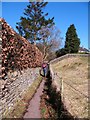
Glusburn footpath
Village footpath leading towards the top end of Glusburn.
Image: © Gordon Hatton
Taken: 7 Mar 2010
0.02 miles
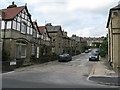
4
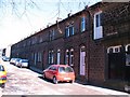
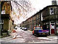
Institute Street, Glusburn
Part of the model village developed by local mill owner Sir John Horsfall in the mid to late 19th century. Good solid gritstone cottages with arched ground floor windows.
Image: © Gordon Hatton
Taken: 7 Mar 2010
0.08 miles
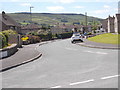
5
Green Way - viewed from Valley View
Image: © Betty Longbottom
Taken: 4 Jul 2016
0.08 miles
6
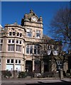
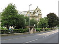
Glusburn Institute
A rather splendid public building in the village of Glusburn. Built over a period of years between 1892 and 1911 [when the clock tower and dome were added] for Sir John Horsfall, local mill owner and benefactor. The building housed an auditorium with stage, dining and reading rooms, a swimming pool and a Baptist chapel.
Image: © Gordon Hatton
Taken: 7 Mar 2010
0.09 miles
7
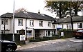
Sunnybank House - Institute Street
This is an Anchor Housing Complex.
Image: © Betty Longbottom
Taken: 28 Oct 2008
0.09 miles
9
Glusburn Institute
Built at a time when the external appearance of buildings was considered important, this splendid Institute opened its doors in 1911. It seems to fulfil a whole range of purposes.
Image: © Dr Neil Clifton
Taken: 18 Aug 2009
0.09 miles
10
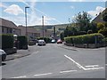
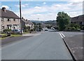
Glusburn: Croft Street
Croft Street leads northwards from the A6068, and is almost exactly on the important 2 degree meridian.
Image: © Dr Neil Clifton
Taken: 18 Aug 2009
0.10 miles