IMAGES TAKEN NEAR TO
Lund Avenue, KEIGHLEY, BD20 8FN
Introduction
This page details the photographs taken nearby to Lund Avenue, BD20 8FN by members of the Geograph project.
The Geograph project started in 2005 with the aim of publishing, organising and preserving representative images for every square kilometre of Great Britain, Ireland and the Isle of Man.

There are currently over 7.5m images from over14,400 individuals and you can help contribute to the project by visiting https://www.geograph.org.uk
Image Map (Loading...)


Getting Data...Please wait
Leaflet Map data © OpenStreetMap
Images are licensed for reuse under creativecommons.org/licenses/by-sa/2.0
Notes
- Clicking on the map will re-center to the selected point.
- The higher the marker number, the further away the image location is from the centre of the postcode.
Image Listing (26 Images Found)
Images are licensed for reuse under creativecommons.org/licenses/by-sa/2.0
Image
Details
Distance
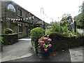
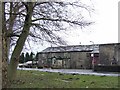
1
The Dog and Gun Inn
Traditional watering hole for the staff at nearby Malsis Hall School, on the A6068 Glusburn/Cowling Road.
Image: © Chris Heaton
Taken: 24 Jun 2008
0.03 miles
2
Glusburn - Dog & Gun
On the Colne Road is this large roadhouse, now a Timothy Taylor pub. This former farmhouse and coaching inn thrived when Glusburn was forced to be a "dry" village.
Image: © Colin Smith
Taken: 7 Aug 2022
0.04 miles
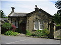
3
Malsis School, Golf Course
This preparatory school outside Cross Hills boasts its own golf course.
Image: © Chris Heaton
Taken: 24 Jun 2008
0.08 miles
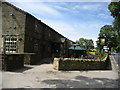
4
Lodge, Malsis School
Lodge building at the entrance to Malsis Hall Preparatory School from the A6068.
Image: © Chris Heaton
Taken: 24 Jun 2008
0.08 miles
5
Glusburn Boundary Stone
Beside the A6068, near Glusburn Bridge.
Image: © David Rogers
Taken: 9 Feb 2010
0.09 miles
6
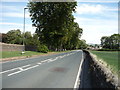
Colne Road (A6068) towards Keighley
Looking north east.
Image: © JThomas
Taken: 11 Aug 2018
0.10 miles
7
Dog and Gun - between Cowling and Glusburn
Timothy Taylors pub
Image: © al partington
Taken: 21 Feb 2006
0.12 miles
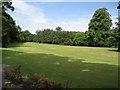
8
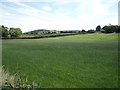
Grassland, High Malsis Farm
Off Colne Road (A6068).
Image: © JThomas
Taken: 11 Aug 2018
0.12 miles
9
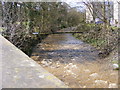
Gill Beck. Compare to an adjacent photo!
http://www.geograph.org.uk/photo/724725
Image: © Allan Friswell
Taken: 12 Apr 2008
0.12 miles
10
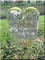
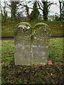
Old Boundary Marker by the A6068, Colne Road, Glusburn and Cross Hills Parish
Parish Boundary Marker by the A6068, in parish of Glusburn and Cross Hills (Craven District), Glusburn, North side of A6068 100m West of Glusburn Bridge.
Inscription reads:-
: E S / Sutton : : H D / Glusburn :
Grade II listed. List Entry Number: 1131819
https://historicengland.org.uk/listing/the-list/list-entry/1131819
Surveyed
Milestone Society National ID: YW_GLUSUT01pb
Image: © Milestone Society
Taken: Unknown
0.14 miles