IMAGES TAKEN NEAR TO
Keighley Road, KEIGHLEY, BD20 7RY
Introduction
This page details the photographs taken nearby to Keighley Road, BD20 7RY by members of the Geograph project.
The Geograph project started in 2005 with the aim of publishing, organising and preserving representative images for every square kilometre of Great Britain, Ireland and the Isle of Man.

There are currently over 7.5m images from over14,400 individuals and you can help contribute to the project by visiting https://www.geograph.org.uk
Image Map
Images are licensed for reuse under creativecommons.org/licenses/by-sa/2.0
Notes
- Clicking on the map will re-center to the selected point.
- The higher the marker number, the further away the image location is from the centre of the postcode.
Image Listing (39 Images Found)
Images are licensed for reuse under creativecommons.org/licenses/by-sa/2.0
Image
Details
Distance
1
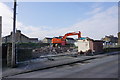
The site of St Joseph's Chapel
A former Catholic church which has been demolished to make way for new housing.
Image: © Bill Boaden
Taken: 20 Mar 2015
0.02 miles
2
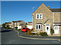
Westland Close, Cross Hills
Modern housing on the edge of the village. Westland Close is an offshoot from Clayton Hall Road.
Image: © Mary and Angus Hogg
Taken: 18 Oct 2018
0.04 miles
3
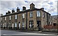
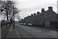
Keighley Road houses, #34 North View at right hand end
Ordnance Survey records indicate that a benchmark levelled at 96.378m above Newlyn Datum in 1956 was verified on the front of #34 in 1962
Image: © Roger Templeman
Taken: 25 Mar 2021
0.05 miles
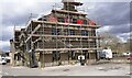
4
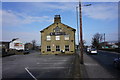
The Zolsha, Cross Hills
An Indian restaurant in a former pub.
Image: © Bill Boaden
Taken: 20 Mar 2015
0.06 miles
5
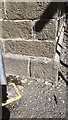
Benchmark on Zolsha Indian Restaurant
Ordnance Survey cut mark benchmark described on the Bench Mark Database at www.bench-marks.org.uk/bm89639
Image: © Roger Templeman
Taken: 25 Mar 2021
0.06 miles
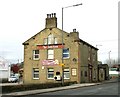
6
Zolsha Indian Restaurant, formerly The Dalesway pub
There is an Ordnance Survey benchmark Image on the left hand side of the building at its front corner
Image: © Roger Templeman
Taken: 25 Mar 2021
0.06 miles
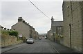
10
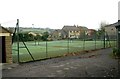
Keighley Road, Cross Hills
Part of the A6068 in the Aire valley.
Image: © Bill Boaden
Taken: 20 Mar 2015
0.08 miles