IMAGES TAKEN NEAR TO
Cedar Grove, KEIGHLEY, BD20 7QS
Introduction
This page details the photographs taken nearby to Cedar Grove, BD20 7QS by members of the Geograph project.
The Geograph project started in 2005 with the aim of publishing, organising and preserving representative images for every square kilometre of Great Britain, Ireland and the Isle of Man.

There are currently over 7.5m images from over14,400 individuals and you can help contribute to the project by visiting https://www.geograph.org.uk
Image Map (Loading...)


Getting Data...Please wait
Leaflet Map data © OpenStreetMap
Images are licensed for reuse under creativecommons.org/licenses/by-sa/2.0
Notes
- Clicking on the map will re-center to the selected point.
- The higher the marker number, the further away the image location is from the centre of the postcode.
Image Listing (111 Images Found)
Images are licensed for reuse under creativecommons.org/licenses/by-sa/2.0
Image
Details
Distance

2
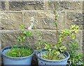
Sutton in Craven, 19 Hazel Grove
The benchmark is cut into the gable end of the property.
Image: © Mel Towler
Taken: 25 Apr 2022
0.05 miles
3

Sutton in Craven, Hazel Grove
There is a benchmark cut into the gable end of the property.
Image: © Mel Towler
Taken: 25 Apr 2022
0.05 miles
4
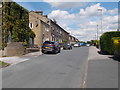
Hazel Grove - viewed from Bent Lane
Image: © Betty Longbottom
Taken: 4 Jul 2016
0.06 miles

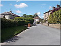
7
Hazel Grove Road - viewed from Bent Lane
Image: © Betty Longbottom
Taken: 4 Jul 2016
0.07 miles
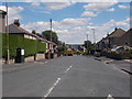
8
Bent Lane - viewed from Hazel Grove Road
Image: © Betty Longbottom
Taken: 4 Jul 2016
0.08 miles
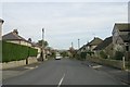
9

Elm Road, Sutton-in-Craven
One of the older roads in the village, as suggested by the lack of pavements. It appears on the 1894 map.
Image: © Stephen Craven
Taken: 21 Jan 2023
0.08 miles
