IMAGES TAKEN NEAR TO
Earls View, KEIGHLEY, BD20 7PR
Introduction
This page details the photographs taken nearby to Earls View, BD20 7PR by members of the Geograph project.
The Geograph project started in 2005 with the aim of publishing, organising and preserving representative images for every square kilometre of Great Britain, Ireland and the Isle of Man.

There are currently over 7.5m images from over14,400 individuals and you can help contribute to the project by visiting https://www.geograph.org.uk
Image Map (Loading...)


Getting Data...Please wait
Leaflet Map data © OpenStreetMap
Images are licensed for reuse under creativecommons.org/licenses/by-sa/2.0
Notes
- Clicking on the map will re-center to the selected point.
- The higher the marker number, the further away the image location is from the centre of the postcode.
Image Listing (96 Images Found)
Images are licensed for reuse under creativecommons.org/licenses/by-sa/2.0
Image
Details
Distance
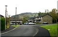
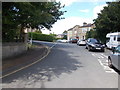
3
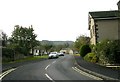
Kings Arms, Sutton-in-Craven
At the junction of North Road and High Street.
Image: © David Rogers
Taken: 23 Oct 2009
0.05 miles
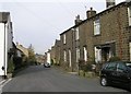
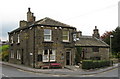
4
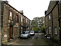
High Street, Sutton-in-Craven
This house is believed to be the setting for the scene in Jane Eyre (deleted from some later editions) in which the heroine's illegitimate baby is devoured by an Alsatian; The National Trust.
Image: © David Rogers
Taken: 23 Oct 2009
0.05 miles
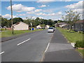
6
Rosewood Square - High Street, Sutton
Image: © Betty Longbottom
Taken: 29 Oct 2008
0.06 miles