IMAGES TAKEN NEAR TO
Holmroyd Avenue, KEIGHLEY, BD20 7LH
Introduction
This page details the photographs taken nearby to Holmroyd Avenue, BD20 7LH by members of the Geograph project.
The Geograph project started in 2005 with the aim of publishing, organising and preserving representative images for every square kilometre of Great Britain, Ireland and the Isle of Man.

There are currently over 7.5m images from over14,400 individuals and you can help contribute to the project by visiting https://www.geograph.org.uk
Image Map (Loading...)


Getting Data...Please wait
Leaflet Map data © OpenStreetMap
Images are licensed for reuse under creativecommons.org/licenses/by-sa/2.0
Notes
- Clicking on the map will re-center to the selected point.
- The higher the marker number, the further away the image location is from the centre of the postcode.
Image Listing (91 Images Found)
Images are licensed for reuse under creativecommons.org/licenses/by-sa/2.0
Image
Details
Distance
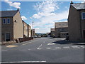
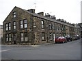
2
Victoria Road - Holme Lane, Cross Hills
Image: © Betty Longbottom
Taken: 28 Oct 2008
0.04 miles

6
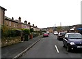
Boundary Avenue - Holme Lane, Cross Hills
Image: © Betty Longbottom
Taken: 28 Oct 2008
0.07 miles
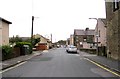
7
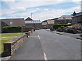
Boundary Avenue - looking towards Holme Lane
Image: © Betty Longbottom
Taken: 4 Jul 2016
0.07 miles
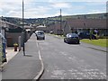
8
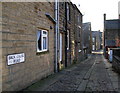
Back Colne Road, Cross Hills
Looking towards Ash Street from Holme L.ne,
Image: © David Rogers
Taken: 4 Dec 2009
0.07 miles
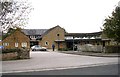
9
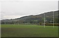
South Craven School Playing Fields - Holme Lane, Cross Hills
Image: © Betty Longbottom
Taken: 28 Oct 2008
0.07 miles