IMAGES TAKEN NEAR TO
West Lane, KEIGHLEY, BD20 7AU
Introduction
This page details the photographs taken nearby to West Lane, BD20 7AU by members of the Geograph project.
The Geograph project started in 2005 with the aim of publishing, organising and preserving representative images for every square kilometre of Great Britain, Ireland and the Isle of Man.

There are currently over 7.5m images from over14,400 individuals and you can help contribute to the project by visiting https://www.geograph.org.uk
Image Map (Loading...)


Getting Data...Please wait
Leaflet Map data © OpenStreetMap
Images are licensed for reuse under creativecommons.org/licenses/by-sa/2.0
Notes
- Clicking on the map will re-center to the selected point.
- The higher the marker number, the further away the image location is from the centre of the postcode.
Image Listing (4 Images Found)
Images are licensed for reuse under creativecommons.org/licenses/by-sa/2.0
Image
Details
Distance
1
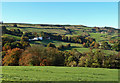
Towards Croft Head Farm
A mid-October view of the Yorkshire Dales, looking across the deep valley of Lumb Clough Beck towards Croft Head Farm.
Image: © Mary and Angus Hogg
Taken: 18 Oct 2018
0.14 miles
2

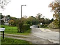
Footbridge over unnamed beck
Strangely, the PRoW that uses this footbridge is not marked on the 1:50000 map. The bridge looks to be a relatively new construction.
Image: © Gordon Hatton
Taken: 7 Mar 2010
0.18 miles