IMAGES TAKEN NEAR TO
Falcon Cliffe, KEIGHLEY, BD20 6QQ
Introduction
This page details the photographs taken nearby to Falcon Cliffe, BD20 6QQ by members of the Geograph project.
The Geograph project started in 2005 with the aim of publishing, organising and preserving representative images for every square kilometre of Great Britain, Ireland and the Isle of Man.

There are currently over 7.5m images from over14,400 individuals and you can help contribute to the project by visiting https://www.geograph.org.uk
Image Map
Images are licensed for reuse under creativecommons.org/licenses/by-sa/2.0
Notes
- Clicking on the map will re-center to the selected point.
- The higher the marker number, the further away the image location is from the centre of the postcode.
Image Listing (97 Images Found)
Images are licensed for reuse under creativecommons.org/licenses/by-sa/2.0
Image
Details
Distance
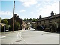
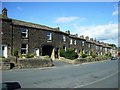
2
Looking down High Street from Falconcliffe
Image: © Betty Longbottom
Taken: 25 Aug 2015
0.03 miles
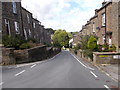
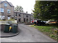
5
Mill Lane, Steeton
Terrace built in the late C19 overlooking the park, the archway gave access to the ash waggon for sanitary purposes.
Image: © Stanley Walker
Taken: 25 Aug 2010
0.05 miles
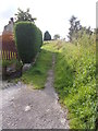
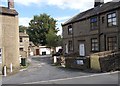
8
Outside toilets at the rear of Mill Lane, Steeton
Image: © Stanley Walker
Taken: 25 Aug 2010
0.06 miles
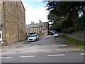
9
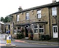
Goat's Head - Skipton Road, Steeton
Image: © Betty Longbottom
Taken: 5 Sep 2007
0.08 miles
10
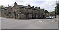
Goats Head pub at School Street / Skipton Road junction
Image: © Luke Shaw
Taken: 17 May 2022
0.08 miles