IMAGES TAKEN NEAR TO
Tarn Court, KEIGHLEY, BD20 6NW
Introduction
This page details the photographs taken nearby to Tarn Court, BD20 6NW by members of the Geograph project.
The Geograph project started in 2005 with the aim of publishing, organising and preserving representative images for every square kilometre of Great Britain, Ireland and the Isle of Man.

There are currently over 7.5m images from over14,400 individuals and you can help contribute to the project by visiting https://www.geograph.org.uk
Image Map (Loading...)


Getting Data...Please wait
Leaflet Map data © OpenStreetMap
Images are licensed for reuse under creativecommons.org/licenses/by-sa/2.0
Notes
- Clicking on the map will re-center to the selected point.
- The higher the marker number, the further away the image location is from the centre of the postcode.
Image Listing (42 Images Found)
Images are licensed for reuse under creativecommons.org/licenses/by-sa/2.0
Image
Details
Distance
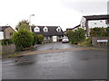
2
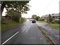
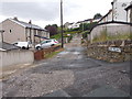
Black Hill Lane - viewed from West Lane
Image: © Betty Longbottom
Taken: 6 Jul 2015
0.03 miles
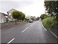
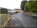
4
Shann Lane
This lane lies on the NW edge of Keighley.
Image: © Mary and Angus Hogg
Taken: 18 Oct 2018
0.05 miles
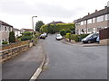
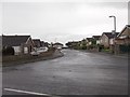
8
Black Hill Lane, Keighley (BD20)
Looking south-eastward.
Image: © Peter Wood
Taken: 9 Jan 2019
0.10 miles
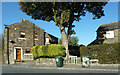
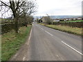
10
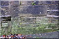
Benchmark on Braithwaite Road wall
Ordnance Survey cut mark benchmark described on the Bench Mark Database at http://www.bench-marks.org.uk/bm73300
Image: © Roger Templeman
Taken: 21 Nov 2017
0.11 miles