IMAGES TAKEN NEAR TO
Elder Street, KEIGHLEY, BD20 6EP
Introduction
This page details the photographs taken nearby to Elder Street, BD20 6EP by members of the Geograph project.
The Geograph project started in 2005 with the aim of publishing, organising and preserving representative images for every square kilometre of Great Britain, Ireland and the Isle of Man.

There are currently over 7.5m images from over14,400 individuals and you can help contribute to the project by visiting https://www.geograph.org.uk
Image Map (Loading...)


Getting Data...Please wait
Leaflet Map data © OpenStreetMap
Images are licensed for reuse under creativecommons.org/licenses/by-sa/2.0
Notes
- Clicking on the map will re-center to the selected point.
- The higher the marker number, the further away the image location is from the centre of the postcode.
Image Listing (63 Images Found)
Images are licensed for reuse under creativecommons.org/licenses/by-sa/2.0
Image
Details
Distance
4
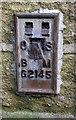
Benchmark on The Roebuck, Skipton Road
Ordnance Survey flush bracket (serial identifier G2145) benchmark described on the Bench Mark Database at http://www.bench-marks.org.uk/bm14163
Image: © Roger Templeman
Taken: 25 Nov 2017
0.02 miles
5
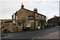
The Roebuck at Skipton Road / Birchwood Road junction
There is an OS flush bracket benchmark Image on the corner of the pub below the Birchwood Road name sign, and a pivot benchmark Image on the Skipton Road face of the same corner.
Image: © Roger Templeman
Taken: 25 Nov 2017
0.03 miles
6
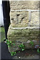
Benchmark on 'The Roebuck', Skipton Road
Ordnance Survey pivot benchmark (with inverted arrow) described on the Bench Mark Database at http://www.bench-marks.org.uk/bm41758
Image: © Roger Templeman
Taken: 25 Nov 2017
0.03 miles
7
Ordnance Survey Pivot Bench Mark
This mark can be found on the wall of The Roebuck Inn, Utley.
For more details see : http://www.bench-marks.org.uk/bm41758
Image: © Peter Wood
Taken: 5 Mar 2012
0.03 miles
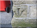
9
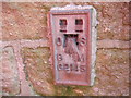
Ordnance Survey Flush Bracket G2145
This bracket can be found on the wall of the Roebuck Inn in Utley.
For more details see : http://www.bench-marks.org.uk/bm14163
Image: © Peter Wood
Taken: 5 Mar 2012
0.03 miles
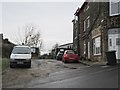
10
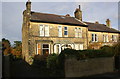
Houses on Green Head Lane
There is an OS benchmark Image on the side of the left hand house at its front corner
Image: © Roger Templeman
Taken: 25 Nov 2017
0.06 miles