IMAGES TAKEN NEAR TO
Green End Road, KEIGHLEY, BD20 5UA
Introduction
This page details the photographs taken nearby to Green End Road, BD20 5UA by members of the Geograph project.
The Geograph project started in 2005 with the aim of publishing, organising and preserving representative images for every square kilometre of Great Britain, Ireland and the Isle of Man.

There are currently over 7.5m images from over14,400 individuals and you can help contribute to the project by visiting https://www.geograph.org.uk
Image Map (Loading...)


Getting Data...Please wait
Leaflet Map data © OpenStreetMap
Images are licensed for reuse under creativecommons.org/licenses/by-sa/2.0
Notes
- Clicking on the map will re-center to the selected point.
- The higher the marker number, the further away the image location is from the centre of the postcode.
Image Listing (22 Images Found)
Images are licensed for reuse under creativecommons.org/licenses/by-sa/2.0
Image
Details
Distance
1
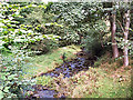
Fenny Shaw Beck at Ousel Hole
Ousel Hole is a peculiar little hamlet tucked away in the wooded valley of the Fenny Shaw Beck. The beck is seen here from the bridge on the hamlet's narrow road.
Image: © David Spencer
Taken: 1 Sep 2005
0.04 miles
4
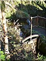
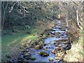
Penstock at Ousel Hole, East Morton
This controlled flow to Botany Mill. The weir is in the background, with a considerable drop over it.
Image: © Humphrey Bolton
Taken: 6 Nov 2011
0.05 miles
6
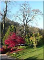
Red maple at Ousel Hole, East Morton
Image: © Humphrey Bolton
Taken: 6 Nov 2011
0.06 miles
7
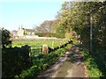
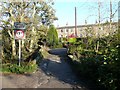
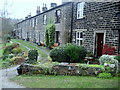
Providence Row, Ousel Hole, East Morton
Perhaps built for workers at Botany Mill nearby.
Image: © Humphrey Bolton
Taken: 6 Nov 2011
0.07 miles
8
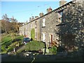
Cottages at Ousel Hole
Terraced dwellings at Ousel Hole above Morton Beck.
Image: © Chris Heaton
Taken: 26 Nov 2008
0.08 miles
9
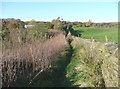
Footpath to Ousel Hole and Sunny Dale, East Morton
Image: © Humphrey Bolton
Taken: 6 Nov 2011
0.15 miles
10
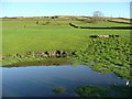
Pond in a field, East Morton
This is at the bottom of the field, dammed by a strip of land containing a footpath. It has probably been made for cattle to drink from. In the distance there is a disused quarry.
Image: © Humphrey Bolton
Taken: 6 Nov 2011
0.15 miles