IMAGES TAKEN NEAR TO
Banks Lane, KEIGHLEY, BD20 5DN
Introduction
This page details the photographs taken nearby to Banks Lane, BD20 5DN by members of the Geograph project.
The Geograph project started in 2005 with the aim of publishing, organising and preserving representative images for every square kilometre of Great Britain, Ireland and the Isle of Man.

There are currently over 7.5m images from over14,400 individuals and you can help contribute to the project by visiting https://www.geograph.org.uk
Image Map
Images are licensed for reuse under creativecommons.org/licenses/by-sa/2.0
Notes
- Clicking on the map will re-center to the selected point.
- The higher the marker number, the further away the image location is from the centre of the postcode.
Image Listing (40 Images Found)
Images are licensed for reuse under creativecommons.org/licenses/by-sa/2.0
Image
Details
Distance
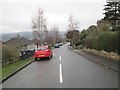
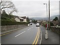
1

Banks Lane climbing towards The Height
Image: © Mat Fascione
Taken: 13 Aug 2016
0.04 miles
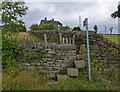
3
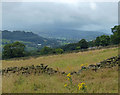
Dry stone wall next to Banks Lane
Looking across the Aire valley towards Steeton and Silsden.
Image: © Mat Fascione
Taken: 13 Aug 2016
0.08 miles
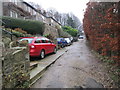
4
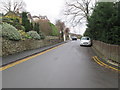
Western Avenue - viewed from Dunkirk Rise
Image: © Betty Longbottom
Taken: 4 Jan 2014
0.09 miles
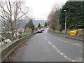
5
Dunkirk Rise - viewed from Western Avenue
Image: © Betty Longbottom
Taken: 4 Jan 2014
0.10 miles
6
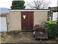
Electricity Substation No 886 - Dunkirk Rise
Image: © Betty Longbottom
Taken: 4 Jan 2014
0.12 miles