IMAGES TAKEN NEAR TO
Ryefield Way, KEIGHLEY, BD20 0DL
Introduction
This page details the photographs taken nearby to Ryefield Way, BD20 0DL by members of the Geograph project.
The Geograph project started in 2005 with the aim of publishing, organising and preserving representative images for every square kilometre of Great Britain, Ireland and the Isle of Man.

There are currently over 7.5m images from over14,400 individuals and you can help contribute to the project by visiting https://www.geograph.org.uk
Image Map
Images are licensed for reuse under creativecommons.org/licenses/by-sa/2.0
Notes
- Clicking on the map will re-center to the selected point.
- The higher the marker number, the further away the image location is from the centre of the postcode.
Image Listing (146 Images Found)
Images are licensed for reuse under creativecommons.org/licenses/by-sa/2.0
Image
Details
Distance
1
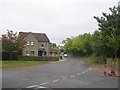
Hainsworth Road - viewed from Belton Road
Image: © Betty Longbottom
Taken: 29 Sep 2009
0.02 miles
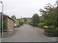
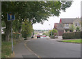
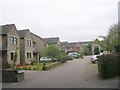
2
Ryefield Way - looking towards Belton Road
Image: © Betty Longbottom
Taken: 27 Apr 2015
0.03 miles
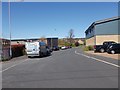
3
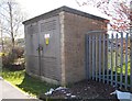
Electricity Substation No 43389 - Ryefield Way
Image: © Betty Longbottom
Taken: 27 Apr 2015
0.04 miles
4
Hainsworth Road - viewed from Belton Road
Image: © Betty Longbottom
Taken: 29 Sep 2009
0.05 miles
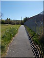
5
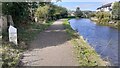
The canal at Silsden
Just starting to rain, again
Image: © John Slater
Taken: 30 Jun 2012
0.07 miles
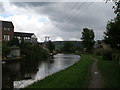
6
Leeds and Liverpool Canal heading NW into Silsden at 22¼ miles from Leeds
There is a canal milepost Image on the left hand side of the towpath
Image: © Roger Templeman
Taken: 18 Sep 2024
0.07 miles
8
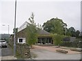
Ecology Building Society - Belton Road
Note the turf roof!
Image: © Betty Longbottom
Taken: 29 Sep 2009
0.07 miles