IMAGES TAKEN NEAR TO
Tunnicliffe Place, KEIGHLEY, BD20 0DH
Introduction
This page details the photographs taken nearby to Tunnicliffe Place, BD20 0DH by members of the Geograph project.
The Geograph project started in 2005 with the aim of publishing, organising and preserving representative images for every square kilometre of Great Britain, Ireland and the Isle of Man.

There are currently over 7.5m images from over14,400 individuals and you can help contribute to the project by visiting https://www.geograph.org.uk
Image Map
Images are licensed for reuse under creativecommons.org/licenses/by-sa/2.0
Notes
- Clicking on the map will re-center to the selected point.
- The higher the marker number, the further away the image location is from the centre of the postcode.
Image Listing (265 Images Found)
Images are licensed for reuse under creativecommons.org/licenses/by-sa/2.0
Image
Details
Distance

2
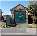
Electricity Substation No 198 - Millfields
Image: © Betty Longbottom
Taken: 27 Apr 2015
0.03 miles
3
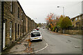
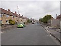
Elliott Street, Silsden near Prince Street
Image: © Mark Anderson
Taken: 14 Nov 2021
0.03 miles
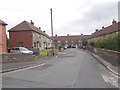

6
Elliott Street - looking towards Kirkgate
Image: © Betty Longbottom
Taken: 27 Apr 2015
0.04 miles
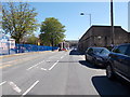
7
Taylor Avenue - looking towards Elliott Street
Image: © Betty Longbottom
Taken: 7 Sep 2015
0.05 miles
8

Strawberry Street - Elliott Street
Image: © Betty Longbottom
Taken: 29 Sep 2009
0.06 miles

10
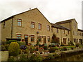
Converted industrial buildings in Silsden
Image: © Andrew Abbott
Taken: 14 Oct 2010
0.07 miles