IMAGES TAKEN NEAR TO
New Road East, CLECKHEATON, BD19 6EW
Introduction
This page details the photographs taken nearby to New Road East, BD19 6EW by members of the Geograph project.
The Geograph project started in 2005 with the aim of publishing, organising and preserving representative images for every square kilometre of Great Britain, Ireland and the Isle of Man.

There are currently over 7.5m images from over14,400 individuals and you can help contribute to the project by visiting https://www.geograph.org.uk
Image Map
Images are licensed for reuse under creativecommons.org/licenses/by-sa/2.0
Notes
- Clicking on the map will re-center to the selected point.
- The higher the marker number, the further away the image location is from the centre of the postcode.
Image Listing (128 Images Found)
Images are licensed for reuse under creativecommons.org/licenses/by-sa/2.0
Image
Details
Distance
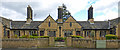
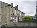
2
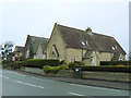
Almshouses, Scholes
Located on New Road East in the village of Scholes
Image: © Chris Heaton
Taken: 29 May 2022
0.01 miles
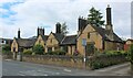
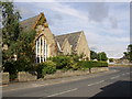
3
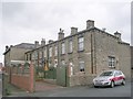
Thompson Jowett Memorial Homes
Almshouses built in 1928 on the north side of New Road, Scholes.
Image: © Paul Glazzard
Taken: 25 Mar 2007
0.01 miles
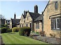
4
The Old Vicarage, Scholes, Cleckheaton
- This is at the end of Greenfield Drive off New Road East. It was called the Old Parsonage and was built in the 18C and rented from the Lord of the Manor to house the incumbents and curates of the White Chapel. It was bought by the Church in 1902, and then enlarged. However it was in a bad state of repair in 1975, and a new vicarage was on the south side of the church. Can anyone date the first-floor window over the door? I would guess early 19C.
Image: © Humphrey Bolton
Taken: 7 Aug 2006
0.02 miles
5
Former school, Scholes
Another contributor's photo from 2005 Image explains that the school dates from 1847-1902 and was later a nursery; it is now housing, as far as I can see.
Image: © Stephen Craven
Taken: 10 Feb 2018
0.03 miles
6
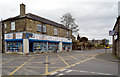
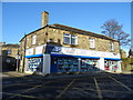
Hardware shop at junction of Tabbs Lane and New Road East
Image: © habiloid
Taken: 4 Apr 2020
0.03 miles
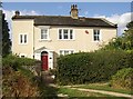
10
National School, Scholes, Cleckheaton
The oldest part of the school was built in 1847. An Infant Department was added in 1870, and further extensions built in 1883 and 1902. In 1944 it became a Church of England Aided School, and from 1973 it has been a nursery school for the under-fives.
Image: © Humphrey Bolton
Taken: 22 Aug 2005
0.04 miles