IMAGES TAKEN NEAR TO
Shaw Street, CLECKHEATON, BD19 6AJ
Introduction
This page details the photographs taken nearby to Shaw Street, BD19 6AJ by members of the Geograph project.
The Geograph project started in 2005 with the aim of publishing, organising and preserving representative images for every square kilometre of Great Britain, Ireland and the Isle of Man.

There are currently over 7.5m images from over14,400 individuals and you can help contribute to the project by visiting https://www.geograph.org.uk
Image Map
Images are licensed for reuse under creativecommons.org/licenses/by-sa/2.0
Notes
- Clicking on the map will re-center to the selected point.
- The higher the marker number, the further away the image location is from the centre of the postcode.
Image Listing (103 Images Found)
Images are licensed for reuse under creativecommons.org/licenses/by-sa/2.0
Image
Details
Distance
1
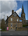
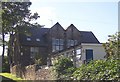
Ash Meadows Care Home, Moorbottom, Cleckheaton
St. Luke's Church is in the background on the right.
Image: © habiloid
Taken: 20 Mar 2020
0.02 miles
2
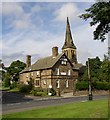
Moorbottom, Cleckheaton
On the left is a former mill-owners house that became the vicarage for St Luke's Church next door, and is now an old people's home.
Image: © Humphrey Bolton
Taken: 22 Aug 2005
0.02 miles
3
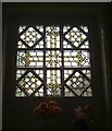
Stained glass window in Westering House, Moorbottom, Cleckheaton
Westering House, shown on the photo of Moorbottom, was built c.1895 for a mill owner, and later became a vicarage. It is now a home for the elderly. The house has several stained glass windows, and this one is in the former study.
Image: © Humphrey Bolton
Taken: 12 Jun 2006
0.02 miles
4
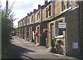
Back St Luke's Terrace, Moorbottom, Cleckheaton
A neat row of through terrace houses, still with the traditional washing hung across the back lane, but updated with satellite dishes and burglar alarms.
Image: © Humphrey Bolton
Taken: 24 Aug 2006
0.02 miles
5
St Luke's School, Moorbottom, Cleckheaton
Tucked away between the church and St Luke's Terrace.
Image: © Humphrey Bolton
Taken: 24 Aug 2006
0.02 miles
6
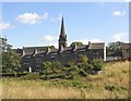
St Luke's Terrace, Moorbottom, Cleckheaton
The front of the houses looks out over the field behind. There is a shared path up through the gardens, but no road. The spire of St Luke's Church can be seen behind.
Image: © Humphrey Bolton
Taken: 24 Aug 2006
0.02 miles
8
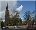
St. Luke's Church, Moorbottom, Cleckheaton
Image: © habiloid
Taken: 20 Mar 2020
0.03 miles
9
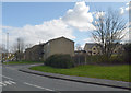
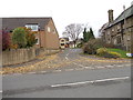
Junction of Moorbottom (A 643) and Shaw Street, Cleckheaton
Image: © habiloid
Taken: 20 Mar 2020
0.03 miles
10
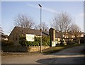
The former Broomfield Methodist Church
Just in Liversedge as the boundary with Cleckheaton goes up the driveway to the right. This chapel was built in the 1980s, and is hidden away amongst houses. It is on the site of an earlier chapel.
Image: © Humphrey Bolton
Taken: 23 Mar 2006
0.04 miles