IMAGES TAKEN NEAR TO
Moorbottom, CLECKHEATON, BD19 6AE
Introduction
This page details the photographs taken nearby to Moorbottom, BD19 6AE by members of the Geograph project.
The Geograph project started in 2005 with the aim of publishing, organising and preserving representative images for every square kilometre of Great Britain, Ireland and the Isle of Man.

There are currently over 7.5m images from over14,400 individuals and you can help contribute to the project by visiting https://www.geograph.org.uk
Image Map
Images are licensed for reuse under creativecommons.org/licenses/by-sa/2.0
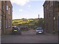
Notes
- Clicking on the map will re-center to the selected point.
- The higher the marker number, the further away the image location is from the centre of the postcode.
Image Listing (125 Images Found)
Images are licensed for reuse under creativecommons.org/licenses/by-sa/2.0
Image
Details
Distance
1
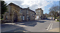
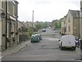
Moorside (A 643), Cleckheaton
The Broomfield pub and the last remaining part of Broomfield Mill can be seen here.
Image: © habiloid
Taken: 20 Mar 2020
0.01 miles
3
Moorside (A 643), Cleckheaton
The road joining Moorside here is West End Drive. A close-up of the post box can be seen in Image
Image: © habiloid
Taken: 20 Mar 2020
0.02 miles
4
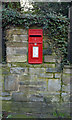
Post box, Moorside (A 643), Cleckheaton
This postbox can be seen in context in Image
Image: © habiloid
Taken: 20 Mar 2020
0.02 miles
8
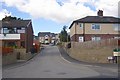
Bream Avenue, Westgate, Cleckheaton
The land behind these houses had no obvious means of access to enable a housing estate to be built. The developer, however, has managed to squeeze a road between two adjacent houses. I wonder if he had to buy them both?
Image: © Humphrey Bolton
Taken: 24 Aug 2006
0.05 miles
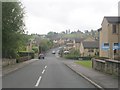
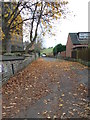
9
Brick Street, Westgate, Cleckheaton
This seems to have been constructed to give access to factories; there was a mill on the left of which the painted wall might have been a part. The street stops at Blacup Beck, which is the boundary with Liversedge. I did not notice that rather grand doorway on the right, or else I would have included all of it in the photo; it was the contrast between the drab street and the sunlit hillside in the distance that took my eye.
Image: © Humphrey Bolton
Taken: 24 Aug 2006
0.05 miles
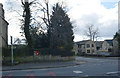
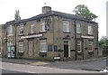
10
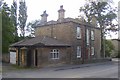
House, lodge and gatepost, Westgate, Cleckheaton
The tall window in the centre of the house probably lights the staircase. At the lower right of the house the wall has been chamfered, presumably to make room for a path up to the front door. The corner of the lodge roof has also been chamfered - perhaps large vehicles needed access to the yard behind, and were damaging the projecting roof?
Image: © Humphrey Bolton
Taken: 24 Aug 2006
0.05 miles