IMAGES TAKEN NEAR TO
Cambridge Chase, CLECKHEATON, BD19 4PW
Introduction
This page details the photographs taken nearby to Cambridge Chase, BD19 4PW by members of the Geograph project.
The Geograph project started in 2005 with the aim of publishing, organising and preserving representative images for every square kilometre of Great Britain, Ireland and the Isle of Man.

There are currently over 7.5m images from over14,400 individuals and you can help contribute to the project by visiting https://www.geograph.org.uk
Image Map
Images are licensed for reuse under creativecommons.org/licenses/by-sa/2.0
Notes
- Clicking on the map will re-center to the selected point.
- The higher the marker number, the further away the image location is from the centre of the postcode.
Image Listing (187 Images Found)
Images are licensed for reuse under creativecommons.org/licenses/by-sa/2.0
Image
Details
Distance
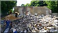
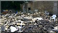
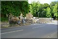
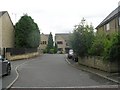
1

Farm buildings in Gomersal
These farm buildings are at the top of the Rhubarb Fields in Gomersal. The path that goes through these fields is the Spen Valley Heritage Trail.
Image: © Nigel Auty
Taken: 7 Oct 2006
0.02 miles
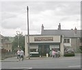
7
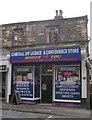
Gomersal Off Licence & Convenience Store - Oxford Road
Image: © Betty Longbottom
Taken: 31 Jul 2010
0.06 miles