IMAGES TAKEN NEAR TO
Mannerley Grove, CLECKHEATON, BD19 4HU
Introduction
This page details the photographs taken nearby to Mannerley Grove, BD19 4HU by members of the Geograph project.
The Geograph project started in 2005 with the aim of publishing, organising and preserving representative images for every square kilometre of Great Britain, Ireland and the Isle of Man.

There are currently over 7.5m images from over14,400 individuals and you can help contribute to the project by visiting https://www.geograph.org.uk
Image Map
Images are licensed for reuse under creativecommons.org/licenses/by-sa/2.0
Notes
- Clicking on the map will re-center to the selected point.
- The higher the marker number, the further away the image location is from the centre of the postcode.
Image Listing (30 Images Found)
Images are licensed for reuse under creativecommons.org/licenses/by-sa/2.0
Image
Details
Distance
1
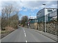
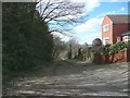
Listing Lane, Gomersal
The modern industrial buildings are on part of the site of the California Foundry.
Image: © Humphrey Bolton
Taken: 4 Apr 2013
0.04 miles

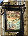
4
The California Inn, Gomersal
On Oxford Road.
Image: © JThomas
Taken: 27 Feb 2020
0.05 miles
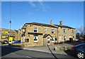
6
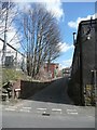
California Lane
A narrow street up the side of the California Foundry, with the California Inn at the top, on the other side of Oxford Road.
Image: © Humphrey Bolton
Taken: 4 Apr 2013
0.06 miles


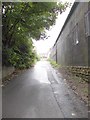
10
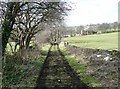
Castle Hill Road
This is where the road reduces to a cart track, which is a public bridleway.
Image: © Humphrey Bolton
Taken: 4 Apr 2013
0.11 miles