IMAGES TAKEN NEAR TO
Kelloe Street, CLECKHEATON, BD19 4EN
Introduction
This page details the photographs taken nearby to Kelloe Street, BD19 4EN by members of the Geograph project.
The Geograph project started in 2005 with the aim of publishing, organising and preserving representative images for every square kilometre of Great Britain, Ireland and the Isle of Man.

There are currently over 7.5m images from over14,400 individuals and you can help contribute to the project by visiting https://www.geograph.org.uk
Image Map
Images are licensed for reuse under creativecommons.org/licenses/by-sa/2.0
Notes
- Clicking on the map will re-center to the selected point.
- The higher the marker number, the further away the image location is from the centre of the postcode.
Image Listing (82 Images Found)
Images are licensed for reuse under creativecommons.org/licenses/by-sa/2.0
Image
Details
Distance

6
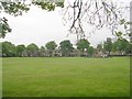
Recreation Ground - Hunsworth Lane
Image: © Betty Longbottom
Taken: 16 May 2009
0.03 miles
7
Stone inscribed ?WR?, Hunsworth Lane
The stone is in the bottom right of the image. See Image for a close view of the stone.
Image: © Humphrey Bolton
Taken: 17 Dec 2012
0.04 miles
8
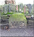
Close view of stone inscribed ?WR?, Hunsworth Lane
It looks as if much of the stone is obscured by the raising of the road and footway levels over the years, and the full inscription might well be ‘WRCC’ for West Riding County Council. The only explanation I can think of for that is that a length of road between here and the bridge over Hunsworth Beck was maintainable by the county rather than urban district council. I remember seeing one in Otterburn Image near to a bridge. That was just inscribed ‘WR’.
Since writing this I have found some more information on the Yorkshire-Milestone site: http://www.yorkshire-milestones.co.uk/index.php?option=com_content&view=article&id=55:county-bridge-stones&catid=1758:-and-other-waymarkers&Itemid=89
Image: © Humphrey Bolton
Taken: 17 Dec 2012
0.04 miles
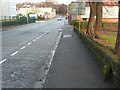
9
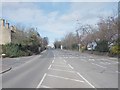
Bradford Road - viewed from Snelsins Lane
Image: © Betty Longbottom
Taken: 20 Mar 2012
0.04 miles