IMAGES TAKEN NEAR TO
Plane Trees Close, CLECKHEATON, BD19 4DU
Introduction
This page details the photographs taken nearby to Plane Trees Close, BD19 4DU by members of the Geograph project.
The Geograph project started in 2005 with the aim of publishing, organising and preserving representative images for every square kilometre of Great Britain, Ireland and the Isle of Man.

There are currently over 7.5m images from over14,400 individuals and you can help contribute to the project by visiting https://www.geograph.org.uk
Image Map
Images are licensed for reuse under creativecommons.org/licenses/by-sa/2.0
Notes
- Clicking on the map will re-center to the selected point.
- The higher the marker number, the further away the image location is from the centre of the postcode.
Image Listing (52 Images Found)
Images are licensed for reuse under creativecommons.org/licenses/by-sa/2.0
Image
Details
Distance
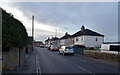
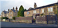
2
Plane Trees Close - Hunsworth Lane
Image: © Betty Longbottom
Taken: 13 Feb 2012
0.04 miles
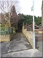
3
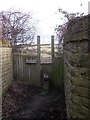
Footpath & Stile - off Savile Park Road
Image: © Betty Longbottom
Taken: 13 Feb 2012
0.05 miles
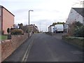
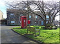
5
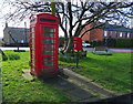
Elizabeth II postbox and telephone box, Hunsworth
Showing position of Postbox No. BD19 704.
See Image] for postbox.
Image: © JThomas
Taken: 27 Feb 2020
0.05 miles
6
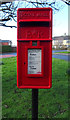
Elizabeth II postbox, Hunsworth
Image: © JThomas
Taken: 27 Feb 2020
0.06 miles
7
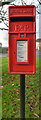
Post box, village green, Hunsworth Lane, Hunsworth
This post box can be seen in context in Image
Image: © habiloid
Taken: 22 Nov 2020
0.06 miles
8
Cottages, Hunsworth
Showing position of Postbox No. BD19 704.
See Image] for postbox.
Image: © JThomas
Taken: 27 Feb 2020
0.06 miles