IMAGES TAKEN NEAR TO
The Maltings, CLECKHEATON, BD19 3EN
Introduction
This page details the photographs taken nearby to The Maltings, BD19 3EN by members of the Geograph project.
The Geograph project started in 2005 with the aim of publishing, organising and preserving representative images for every square kilometre of Great Britain, Ireland and the Isle of Man.

There are currently over 7.5m images from over14,400 individuals and you can help contribute to the project by visiting https://www.geograph.org.uk
Image Map
Images are licensed for reuse under creativecommons.org/licenses/by-sa/2.0
Notes
- Clicking on the map will re-center to the selected point.
- The higher the marker number, the further away the image location is from the centre of the postcode.
Image Listing (107 Images Found)
Images are licensed for reuse under creativecommons.org/licenses/by-sa/2.0
Image
Details
Distance
3
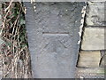
Ordnance Survey Cut Mark
This mark can be found on a gatepost in Whitcliffe Road.
For more details see : http://www.bench-marks.org.uk/bm41845
Image: © Peter Wood
Taken: 9 Mar 2012
0.03 miles
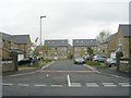
4
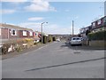
Kenmore Drive - looking towards Kenmore Road
Image: © Betty Longbottom
Taken: 30 Jun 2012
0.05 miles
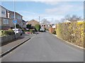
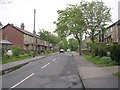
10
Wadsworth Court - Whitcliffe Road
Image: © Betty Longbottom
Taken: 16 May 2009
0.07 miles