IMAGES TAKEN NEAR TO
Beamsley Road, SHIPLEY, BD18 2DR
Introduction
This page details the photographs taken nearby to Beamsley Road, BD18 2DR by members of the Geograph project.
The Geograph project started in 2005 with the aim of publishing, organising and preserving representative images for every square kilometre of Great Britain, Ireland and the Isle of Man.

There are currently over 7.5m images from over14,400 individuals and you can help contribute to the project by visiting https://www.geograph.org.uk
Image Map (Loading...)


Getting Data...Please wait
Leaflet Map data © OpenStreetMap
Images are licensed for reuse under creativecommons.org/licenses/by-sa/2.0
Notes
- Clicking on the map will re-center to the selected point.
- The higher the marker number, the further away the image location is from the centre of the postcode.
Image Listing (173 Images Found)
Images are licensed for reuse under creativecommons.org/licenses/by-sa/2.0
Image
Details
Distance
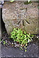
1
Stanley Street at Shipley Fields Road junction
There is an Ordnance Survey benchmark Image on the low wall under a wooden fence at the right hand corner of the junction
Image: © Roger Templeman
Taken: 30 May 2017
0.03 miles
2
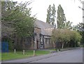
St Margaret's Church, Shipley Fields Road, Shipley
The building of the Church began in spring 1895, and was designed by Messrs H & E Marten. It was opened in May 1896. It was opened without the Sanctuary which took another nine years to build, mostly financed by the women of the congregation, who raised the money by 'sales of work'. The Church was dedicated to St Margaret, and was granted full parish status in March 1909.
Image: © Humphrey Bolton
Taken: 10 Sep 2007
0.04 miles
3
Benchmark on wall fronting #74 Shipley Fields Road
Ordnance Survey rivet benchmark described on the Bench Mark Database at www.bench-marks.org.uk/bm82288
Image: © Roger Templeman
Taken: 30 May 2017
0.04 miles
4
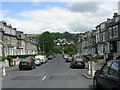
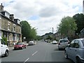
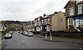
Aireville Road - viewed from Salisbury Street
Image: © Betty Longbottom
Taken: 21 Jun 2009
0.06 miles
5
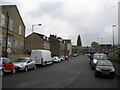
North end of Midland Road, Frizinghall
Image: © Richard Vince
Taken: 15 May 2021
0.06 miles
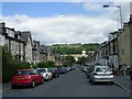
6
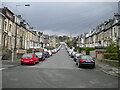
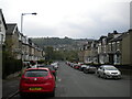
Aireville Road, Frizinghall
In its entirety, viewed from Midland Road towards Keighley Road.
Image: © Richard Vince
Taken: 15 May 2021
0.06 miles
8
Bottom of Aireville Road, Frizinghall
With a view across the valley towards Owlet and Wrose.
Image: © Richard Vince
Taken: 15 May 2021
0.07 miles