1
Olicana House, Chapel Street, Bradford
Steel-framed concrete-clad office block built in 1974. It is also unprepossessing.
A rare interloper in the largely-intact Victorian/Edwardian Little Germany warehouse district.
Occupied by Bradford Council.
Image: © Stephen Richards
Taken: 15 Jun 2012
0.01 miles
2
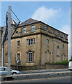
67 East Parade, Bradford
Very plain Edwardian warehouse, built by Mawson & Hudson in 1913.
Image: © Stephen Richards
Taken: 15 Jun 2012
0.01 miles
3
Scoresby Street - Little Germany
Image: © Betty Longbottom
Taken: 23 Sep 2007
0.01 miles
4
Top of Chapel Street, Little Germany, Bradford
Some of these old industrial buildings have been converted to new uses; others look empty.
Image: © Robin Stott
Taken: 21 Oct 2011
0.01 miles
5
Treadwell Mills, Upper Park Gate
Viewed across the Shipley / Airedale Road. Like many other former mill buildings, it has been converted into apartments in recent years. The two green boxes are Air Pollution Monitoring Stations. The smaller one is permanently sited, but the large one is a mobile unit which has just arrived in the last few days. In March 2010, the Shipley Airedale Road was named as the most polluted road in Britain. See http://www.yorkshirepost.co.uk/news/Revealed-The-most-polluted-street.6184695.jp
Image: © Stephen Armstrong
Taken: 23 Aug 2010
0.01 miles
6
Former Dawsons Mill
This mill building on Upper Park Gate is listed grade II (List Entry Number 1104863) and dated to "c.1865".
Image: © Stephen Craven
Taken: 30 Dec 2011
0.01 miles
7
Dawson's Mill, NE side of Upper Park Gate
There is an Ordnance Survey benchmark
Image right of the door. Ordnance Survey documents refer to the building as an art gallery, but not sure the period of such use. The building is now converted to apartments
Image: © Roger Templeman
Taken: 15 Jun 2017
0.01 miles
8
Benchmark on former Dawson's Mill
Ordnance Survey cut mark benchmark described on the Bench Mark Database at www.bench-marks.org.uk/bm85539
Image: © Roger Templeman
Taken: 15 Jun 2017
0.02 miles
9
99 East Parade, Bradford
Incorporated into a C19th warehouse is this rather mauled early C19th house, quite the rarity in Bradford. It has a number of Venetian windows. Grade II listed.
Image: © Stephen Richards
Taken: 15 Jun 2012
0.03 miles
10
View from Humboldt Street, Bradford
Looking across Shipley Airedale Road towards Little Germany, East Parade running down on the right. The bulky warehouse centre-left is
Image The chimney belongs to an engine house attached to another warehouse.
Image: © Stephen Richards
Taken: 15 Jun 2012
0.03 miles


