IMAGES TAKEN NEAR TO
Barkerend Road, BRADFORD, BD1 4EP
Introduction
This page details the photographs taken nearby to Barkerend Road, BD1 4EP by members of the Geograph project.
The Geograph project started in 2005 with the aim of publishing, organising and preserving representative images for every square kilometre of Great Britain, Ireland and the Isle of Man.

There are currently over 7.5m images from over14,400 individuals and you can help contribute to the project by visiting https://www.geograph.org.uk
Image Map
Images are licensed for reuse under creativecommons.org/licenses/by-sa/2.0
Notes
- Clicking on the map will re-center to the selected point.
- The higher the marker number, the further away the image location is from the centre of the postcode.
Image Listing (791 Images Found)
Images are licensed for reuse under creativecommons.org/licenses/by-sa/2.0
Image
Details
Distance
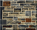
1
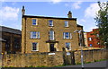
#1 Barkerend Road at Stott Hill junction
There is an Ordnance Survey benchmark Image on the wall fronting the house about 9m left of its entrance. There is also what appears to be the bottom half of another benchmark Image about 3m right of the entrance
Image: © Roger Templeman
Taken: 15 Jun 2017
0.01 miles
2
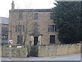
Former Clergy House for Bradford Cathedral - Stott Hill
Image: © Betty Longbottom
Taken: 21 Apr 2014
0.02 miles
3

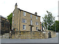
#1 Barkerend Road
The Grade II Listed former clergy house for Bradford Cathedral, which is just out of shot to the left. It was abandoned for several years, but has been totally refurbished in recent years &, together with the new building behind to the right, is now a hostel. There is an OS Cut Benchmark Image on the boundary wall facing the camera.
Image: © Stephen Armstrong
Taken: 4 Nov 2018
0.02 miles
4
Former Diocesan Office, Stott Hill, Bradford
The administrative office of the former Bradford Diocese, opposite the Cathedral. Staff moved at some time (1990s?) to a new offices in Steeton, before the Diocese became part of the new one of Leeds in 2014, and since 2016 the administrative hub has been at Church House in Leeds.
The official address is 1 Barkerend Road, under which entry it is listed grade II (list entry 1133302) as a "town house dating from the latter part of the C18 and therefore a rare survival in central Bradford".
Image: © Stephen Craven
Taken: 15 Jun 2019
0.02 miles
5
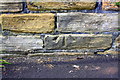
Half a benchmark on the wall in front of #1 Barkerend Road
This appears to be part of an Ordnance Survey cut mark benchmark but there is nothing in OS records to suggest it is. Possibly relocated from somewhere else?
Image: © Roger Templeman
Taken: 15 Jun 2017
0.02 miles
6
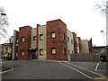
Jermyn Court, Jermyn Street, Bradford
Built by Bradford Council in 2017 as temporary housing for homeless people to save the Council having to pay for bed & breakfast accommodation.
Image: © Stephen Armstrong
Taken: 22 Jan 2022
0.02 miles
7
Old Cathedral Hall, Stott Hill
This building appears no longer to be used as the cathedral hall.
Image: © Stephen Craven
Taken: 30 Dec 2011
0.02 miles
8
Detail of Diocesan Office, Stott Hill, Bradford
A very variegated front.
Image: © Stephen Richards
Taken: 15 Jun 2012
0.02 miles
9

OS Cut Benchmark, Stott Hill
This is on the boundary wall of #1 Barkerend Road at its junction with Stott Hill. Details at https://www.bench-marks.org.uk/bm85422
Image: © Stephen Armstrong
Taken: 4 Nov 2018
0.02 miles
10
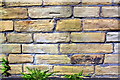
Benchmark on Stott Hill wall in front of #1 Barkerend Road
Ordnance Survey cut mark benchmark described on the Bench Mark Database at www.bench-marks.org.uk/bm85422
Image: © Roger Templeman
Taken: 15 Jun 2017
0.02 miles