IMAGES TAKEN NEAR TO
Hollingwell Hill, BRADFORD, BD14 6PU
Introduction
This page details the photographs taken nearby to Hollingwell Hill, BD14 6PU by members of the Geograph project.
The Geograph project started in 2005 with the aim of publishing, organising and preserving representative images for every square kilometre of Great Britain, Ireland and the Isle of Man.

There are currently over 7.5m images from over14,400 individuals and you can help contribute to the project by visiting https://www.geograph.org.uk
Image Map
Images are licensed for reuse under creativecommons.org/licenses/by-sa/2.0
Notes
- Clicking on the map will re-center to the selected point.
- The higher the marker number, the further away the image location is from the centre of the postcode.
Image Listing (24 Images Found)
Images are licensed for reuse under creativecommons.org/licenses/by-sa/2.0
Image
Details
Distance
1
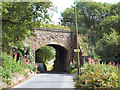
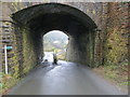
Railway bridge, former Queensbury station
This bridge over Brow Lane (looking eastwards) was at the Keighley end of the celebrated Queensbury station on the Great Northern lines between Halifax, Bradford and Keighley. This station, hundreds of feet below the town it was meant to serve, had a full set of six platforms on a triangle. Note the access ramp (which leads to a farm) at the far side and to the left, tucked under the bridge itself due to the road's steep gradient.
Image: © David Spencer
Taken: 18 Aug 2005
0.09 miles
2
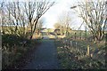
Sustrans Route 69 crossing Brow Lane Bridge
The current OS maps do not yet show this public access route along the disused Queensbury to Keighley railway between the former Queensbury station and Cockin Lane. The green plastic coated wire fences mark the position of Brow Lane bridge.
Image: © Richard Kay
Taken: 24 Nov 2010
0.11 miles
3
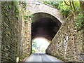
Railway bridge, former Queensbury station
This bridge over Brow Lane (looking westwards) was at the Keighley end of Queensbury station. On the right is an access ramp for a nearby farm, demonstrating the steep upward slope of Brow Lane at this point. The whole structure is massively engineered and unusually wide, as there was an embankment on top, surmounted by the junction and divergence of the lines from Halifax and Bradford.
Image: © David Spencer
Taken: 18 Aug 2005
0.15 miles
4
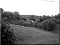
Queensbury station
Another view of the sadly decaying viaduct at the erstwhile Queensbury station. See also Image
Image: © Dr Neil Clifton
Taken: 29 May 1987
0.15 miles
5
Brow Lane passing under a former railway bridge and heading for Clayton
Looking eastward. The bridge now carries feet and cycles along the Great Northern Railway Trail.
Image: © Peter Wood
Taken: 27 Dec 2019
0.15 miles
6
Brow Lane, Clayton
The chimney belongs to the disused Clayton Fireclay and brick Works, and was decorated to celebrate Bradford City's winning of the 1911 FA Cup. Almost a century ago. Perhaps a large chimney could be similarly decorated when England win the 2010 World Cup? See also Image and Image
Image: © Humphrey Bolton
Taken: 24 Jun 2010
0.17 miles
7
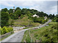
Site of Queensbury station
Queensbury was a triangular junction station with lines to Bradford, Keighley and Halifax (including a branch to St Paul's high level station). This is a view from the Keighley branch, sixty years since the station closed in 1955 (although tracks were not lifted until 1966). See also Image taken in 1987, and http://www.disused-stations.org.uk/q/queensbury/index.shtml has much more detail on the history of the station.
Image: © Stephen Craven
Taken: 8 Aug 2015
0.17 miles
8
Cycling route, Clayton
This is on the former Halifax, Thornton and Keighley Railway.
Image: © Humphrey Bolton
Taken: 24 Jun 2010
0.18 miles
9
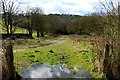
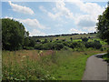
Former Trackbed heading South West from Queensbury
This track used to carry the railway from Queensbury to Halifax - seen here approaching the concealed portal of a long tunnel.
The photograph is taken from the site of Queensbury Station - a 6 platform arrangement designed in a triangle, at least 400 ft below the town it served.
The outline of the station is easier seen from above, than on the same level.
Image: © Chris Heaton
Taken: 21 Mar 2017
0.18 miles
10
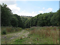
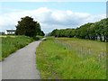
Route of former Queensbury - Halifax railway
Queensbury was a triangular junction station with lines to Bradford, Keighley and Halifax (including a branch to St Paul's high level station). This is a view from the station site looking along the Halifax line, sixty years since the station closed in 1955 (although tracks were not lifted until 1966). See also Image taken in 1987, and http://www.disused-stations.org.uk/q/queensbury/index.shtml has much more detail on the history of the station.
As can be seen from this photo, the station was a long way below Queensbury village (some of whose houses appear on the ridge) and more convenient for railway operaitons than for passengers.
Image: © Stephen Craven
Taken: 8 Aug 2015
0.19 miles