IMAGES TAKEN NEAR TO
Baldwin Lane, BRADFORD, BD14 6PR
Introduction
This page details the photographs taken nearby to Baldwin Lane, BD14 6PR by members of the Geograph project.
The Geograph project started in 2005 with the aim of publishing, organising and preserving representative images for every square kilometre of Great Britain, Ireland and the Isle of Man.

There are currently over 7.5m images from over14,400 individuals and you can help contribute to the project by visiting https://www.geograph.org.uk
Image Map
Images are licensed for reuse under creativecommons.org/licenses/by-sa/2.0
Notes
- Clicking on the map will re-center to the selected point.
- The higher the marker number, the further away the image location is from the centre of the postcode.
Image Listing (36 Images Found)
Images are licensed for reuse under creativecommons.org/licenses/by-sa/2.0
Image
Details
Distance
1
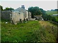
Bradford West Footpath 86 at Brow Top, Clayton
Image: © Humphrey Bolton
Taken: 4 Aug 2022
0.04 miles
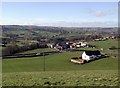
2
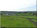
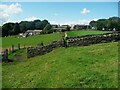
Brow Top and White Acres farms
Two farms utilising relatively level ground in an otherwise hilly area.
Image: © Stephen Craven
Taken: 12 Oct 2019
0.05 miles
3
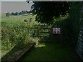
Stile on Bradford West Footpath 89 at Brow Top, Clayton
Image: © Humphrey Bolton
Taken: 4 Aug 2022
0.07 miles
4
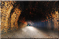
Clayton tunnel
Clayton tunnel is a stones throw from Queensbury. Built by the G.N.R in 1879. A straight 1057yd long tunnel under the village of Clayton. The far portal is buried under new housing. The tunnel itself is in good condition apart from one nasty roof collapse at the far end. There are several bad leaks along the whole structure.
For many more pictures see http://www.flickr.com/photos/phill_dvsn/sets/72157600273013933/detail/
Image: © philld
Taken: 26 May 2007
0.08 miles
5
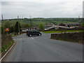
Junction of Back Lane with Baldwin Lane
Image: © Alexander P Kapp
Taken: 10 May 2010
0.11 miles
7
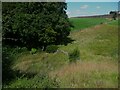
Looking down onto Bradford West Footpath 89 near Myrtle Grove Farm, Clayton
The path is on the other side of the fence.
Image: © Humphrey Bolton
Taken: 4 Aug 2022
0.12 miles
8
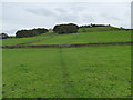
Footpath from Clayton to Clayton Heights
Part of the Bronte Way.
Image: © Stephen Craven
Taken: 12 Oct 2019
0.13 miles

10
Sheep Hill Lane, Old Dolphin
Looking towards the junction of Back Lane and Baldwin Lane from Sheep Hill Lane at Old Dolphin, east of Queensbury.
I've been told the white building at the right hand side of the picture used to be the Queensbury Telephone Exchange, which was sold and converted into a house.
Image: © Paul Glazzard
Taken: 14 Feb 2007
0.13 miles