IMAGES TAKEN NEAR TO
Gaythorne Terrace, BRADFORD, BD14 6LE
Introduction
This page details the photographs taken nearby to Gaythorne Terrace, BD14 6LE by members of the Geograph project.
The Geograph project started in 2005 with the aim of publishing, organising and preserving representative images for every square kilometre of Great Britain, Ireland and the Isle of Man.

There are currently over 7.5m images from over14,400 individuals and you can help contribute to the project by visiting https://www.geograph.org.uk
Image Map
Images are licensed for reuse under creativecommons.org/licenses/by-sa/2.0
Notes
- Clicking on the map will re-center to the selected point.
- The higher the marker number, the further away the image location is from the centre of the postcode.
Image Listing (72 Images Found)
Images are licensed for reuse under creativecommons.org/licenses/by-sa/2.0
Image
Details
Distance
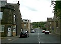
1
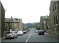
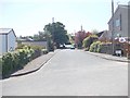
Beaconsfield Road - Pasture Lane, Clayton
Image: © Betty Longbottom
Taken: 17 Sep 2008
0.02 miles
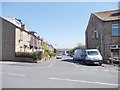
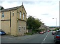
2
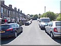
Herbert Street - Gaythorne Terrace
Image: © Betty Longbottom
Taken: 26 May 2012
0.02 miles
4
Cross Street - viewed from Marne Avenue
Image: © Betty Longbottom
Taken: 26 May 2012
0.03 miles
5
Marne Avenue - viewed from Cross Street
Image: © Betty Longbottom
Taken: 26 May 2012
0.03 miles
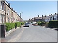
6
Lavinia Terrace - Beaconsfield Road
Image: © Betty Longbottom
Taken: 26 May 2012
0.03 miles
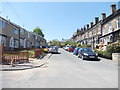
9
Beaconsfield Road, Clayton
This leads to a recreation ground and a golf course belonging to Clayton Golf Club
Image: © Humphrey Bolton
Taken: 19 Aug 2010
0.04 miles
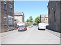
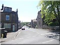
10
Pasture Lane, Clayton
The building on the left is a former Co-op shop.
Image: © Humphrey Bolton
Taken: 19 Aug 2010
0.04 miles