IMAGES TAKEN NEAR TO
Holts Lane, BRADFORD, BD14 6BL
Introduction
This page details the photographs taken nearby to Holts Lane, BD14 6BL by members of the Geograph project.
The Geograph project started in 2005 with the aim of publishing, organising and preserving representative images for every square kilometre of Great Britain, Ireland and the Isle of Man.

There are currently over 7.5m images from over14,400 individuals and you can help contribute to the project by visiting https://www.geograph.org.uk
Image Map
Images are licensed for reuse under creativecommons.org/licenses/by-sa/2.0
Notes
- Clicking on the map will re-center to the selected point.
- The higher the marker number, the further away the image location is from the centre of the postcode.
Image Listing (91 Images Found)
Images are licensed for reuse under creativecommons.org/licenses/by-sa/2.0
Image
Details
Distance
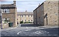
1
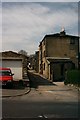
Holts Lane, Clayton
Known locally as Tea Pot Spout
Image: © Alan Longbottom
Taken: 14 Apr 2007
0.01 miles
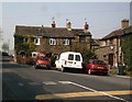
3
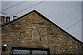
Inscription on old house
I.C.S. 1752
Image: © Alan Longbottom
Taken: 14 Apr 2007
0.04 miles
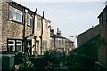
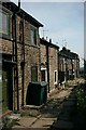
7
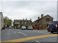
Cottages at Town End Clayton
The road narrows at the left of the cottages and becomes Low Lane.
Image: © Alan Longbottom
Taken: 15 Apr 2007
0.06 miles
8
Cottage at Town End Clayton
This has the date stone ICS 1750
Image: © Alan Longbottom
Taken: 15 Apr 2007
0.06 miles
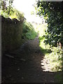
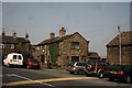
10
Road narrows on Town End Road
Road narrows to one car width as it passes the row of three houses which are square to the road.
Image: © Alexander P Kapp
Taken: 10 May 2010
0.06 miles