IMAGES TAKEN NEAR TO
Hallfield Road, BRADFORD, BD1 3RP
Introduction
This page details the photographs taken nearby to Hallfield Road, BD1 3RP by members of the Geograph project.
The Geograph project started in 2005 with the aim of publishing, organising and preserving representative images for every square kilometre of Great Britain, Ireland and the Isle of Man.

There are currently over 7.5m images from over14,400 individuals and you can help contribute to the project by visiting https://www.geograph.org.uk
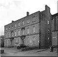
Image Map
Images are licensed for reuse under creativecommons.org/licenses/by-sa/2.0
Notes
- Clicking on the map will re-center to the selected point.
- The higher the marker number, the further away the image location is from the centre of the postcode.
Image Listing (469 Images Found)
Images are licensed for reuse under creativecommons.org/licenses/by-sa/2.0
Image
Details
Distance
2
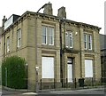
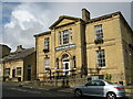
House at junction of Lumb Lane & Hallfield Road
Image: © Betty Longbottom
Taken: 21 Apr 2007
0.03 miles

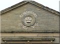
5
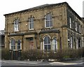
House on Lumb Lane at junction with Hallfield Road
Date stone states that this was built in 1862.
Image: © Betty Longbottom
Taken: 21 Apr 2007
0.03 miles
6
Centre for Deaf People, Hallfield Road, Bradford
Image: © Stephen Armstrong
Taken: 9 Sep 2017
0.03 miles
7

Bradford Central Taxis - Lumb Lane
Image: © Betty Longbottom
Taken: 25 Oct 2009
0.03 miles
8

Centre for Deaf People - Hallfield Road
Image: © Betty Longbottom
Taken: 21 Nov 2010
0.03 miles
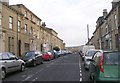
10

Houghton Place - viewed from Hallfield Road
Image: © Betty Longbottom
Taken: 21 Nov 2010
0.05 miles