IMAGES TAKEN NEAR TO
Old Allen Road, BRADFORD, BD13 3RX
Introduction
This page details the photographs taken nearby to Old Allen Road, BD13 3RX by members of the Geograph project.
The Geograph project started in 2005 with the aim of publishing, organising and preserving representative images for every square kilometre of Great Britain, Ireland and the Isle of Man.

There are currently over 7.5m images from over14,400 individuals and you can help contribute to the project by visiting https://www.geograph.org.uk
Image Map (Loading...)


Getting Data...Please wait
Leaflet Map data © OpenStreetMap
Images are licensed for reuse under creativecommons.org/licenses/by-sa/2.0
Notes
- Clicking on the map will re-center to the selected point.
- The higher the marker number, the further away the image location is from the centre of the postcode.
Image Listing (11 Images Found)
Images are licensed for reuse under creativecommons.org/licenses/by-sa/2.0
Image
Details
Distance
1
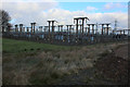
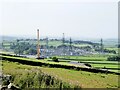
Bradford West Electricity Sub Station
This large sub station is the property of the National Grid, seen here by Harrop Lane.
The countryside, roundabout, is festooned with pylons that seem to march in several directions - all from this spot.
Image: © Chris Heaton
Taken: 22 Dec 2016
0.08 miles
2
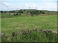
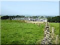
Manor Farm
Seen across a small valley from Black Dyke Lane.
Image: © Christine Johnstone
Taken: 13 Jul 2011
0.10 miles
3
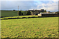
Manor Farm
As seen from Streamhead Road
Image: © Chris Heaton
Taken: 22 Dec 2016
0.11 miles
4
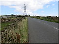
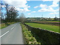
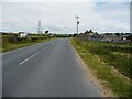
Old Allen Road near Little Moor Top
Looking south-eastward.
Image: © Peter Wood
Taken: 4 Aug 2017
0.13 miles
5
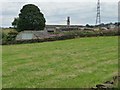
Electricity Sub-station
Isolated in the middle of farmland, viewed from Old Allen Road.
Image: © Kevin Waterhouse
Taken: 6 Sep 2023
0.13 miles
6
Old Allen Road, Allerton / Thornton
This part of the road is the boundary of Thornton.
Image: © Humphrey Bolton
Taken: 5 Apr 2018
0.19 miles
7
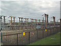
Bradford West National Grid substation
The pylons disfiguring the landscape for miles around in all directions march towards this huge switching station to the east of Harrop Lane serving the city of Bradford.
Image: © David Spencer
Taken: 16 Aug 2005
0.21 miles
8
Converted Nissen hut, Hazel Crook Farm
A new use for an old 'temporary' building.
Image: © Christine Johnstone
Taken: 13 Jul 2011
0.22 miles
9
Black Dyke Lane
Passing Hazel Crook End Farm.
Image: © Christine Johnstone
Taken: 13 Jul 2011
0.22 miles
10
Electricity Sub-station
With a crane at a battery storage facility undergoing construction
Image: © Kevin Waterhouse
Taken: 6 Sep 2023
0.22 miles