IMAGES TAKEN NEAR TO
High Wicken Close, BRADFORD, BD13 3PF
Introduction
This page details the photographs taken nearby to High Wicken Close, BD13 3PF by members of the Geograph project.
The Geograph project started in 2005 with the aim of publishing, organising and preserving representative images for every square kilometre of Great Britain, Ireland and the Isle of Man.

There are currently over 7.5m images from over14,400 individuals and you can help contribute to the project by visiting https://www.geograph.org.uk
Image Map
Images are licensed for reuse under creativecommons.org/licenses/by-sa/2.0
Notes
- Clicking on the map will re-center to the selected point.
- The higher the marker number, the further away the image location is from the centre of the postcode.
Image Listing (126 Images Found)
Images are licensed for reuse under creativecommons.org/licenses/by-sa/2.0
Image
Details
Distance
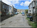
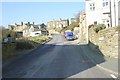
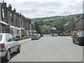
4
Cliffe Street - looking towards Reservoir View
Image: © Betty Longbottom
Taken: 1 Jun 2013
0.03 miles
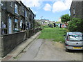
9
King Edward Terrace - looking towards King Edward Road
Image: © Betty Longbottom
Taken: 1 Jun 2013
0.05 miles
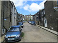
10
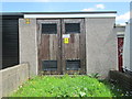
Electricity Substation No 1115 - West Lane
Image: © Betty Longbottom
Taken: 1 Jun 2013
0.06 miles