IMAGES TAKEN NEAR TO
Allerton View, BRADFORD, BD13 3AE
Introduction
This page details the photographs taken nearby to Allerton View, BD13 3AE by members of the Geograph project.
The Geograph project started in 2005 with the aim of publishing, organising and preserving representative images for every square kilometre of Great Britain, Ireland and the Isle of Man.

There are currently over 7.5m images from over14,400 individuals and you can help contribute to the project by visiting https://www.geograph.org.uk
Image Map
Images are licensed for reuse under creativecommons.org/licenses/by-sa/2.0
Notes
- Clicking on the map will re-center to the selected point.
- The higher the marker number, the further away the image location is from the centre of the postcode.
Image Listing (53 Images Found)
Images are licensed for reuse under creativecommons.org/licenses/by-sa/2.0
Image
Details
Distance
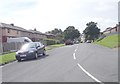
6
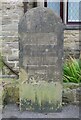
Old Guide stone, School Green, Thornton
Located on the East side of road, outside No. 1. Carved stone post, 18th century.
Inscription reads: TO / defaced / TO {hand to right} /defaced / {hand to left} / 1774
Milestone Society National ID: YW_BFTN03a
Image: © Christine Minto
Taken: 2 Nov 2008
0.08 miles
8
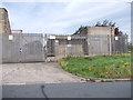
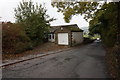
Electricity Substation No 933 - Old Road
Image: © Betty Longbottom
Taken: 1 Sep 2012
0.09 miles