IMAGES TAKEN NEAR TO
Bank Street, BRADFORD, BD1 1EE
Introduction
This page details the photographs taken nearby to Bank Street, BD1 1EE by members of the Geograph project.
The Geograph project started in 2005 with the aim of publishing, organising and preserving representative images for every square kilometre of Great Britain, Ireland and the Isle of Man.

There are currently over 7.5m images from over14,400 individuals and you can help contribute to the project by visiting https://www.geograph.org.uk
Image Map (Loading...)


Getting Data...Please wait
Leaflet Map data © OpenStreetMap
Images are licensed for reuse under creativecommons.org/licenses/by-sa/2.0
Notes
- Clicking on the map will re-center to the selected point.
- The higher the marker number, the further away the image location is from the centre of the postcode.
Image Listing (1448 Images Found)
Images are licensed for reuse under creativecommons.org/licenses/by-sa/2.0
Image
Details
Distance
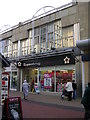
4
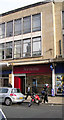
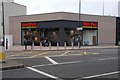
Pizza Pieces and The Po Sing Restaurant, Bank Street, Bradford
Image: © habiloid
Taken: 12 Mar 2003
0.01 miles
7
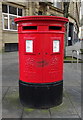
Double aperture Elizabeth II postbox on Bank Street, Bradford
Postbox No. BD1 319 and Postbox No. BD1 1319.
See Image] for context.
Image: © JThomas
Taken: 14 Feb 2020
0.01 miles
8
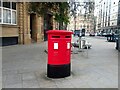
Queen Elizabeth II Postbox, Bank Street, Bradford
Double aperture postbox on Bank Street, near the junction with Broadway. The left hand aperture is BD1 319 & the right hand is BD1 1319.
Image: © Stephen Armstrong
Taken: 8 Sep 2023
0.02 miles
10
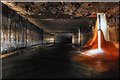
Underground Bradford-The hidden course of the Bradford beck
The Bradford beck runs underground, just higher up from the old Odeon cinema, It twists and turns under Centenary Square before emerging near to Valley Parade football ground.
Unusually for a major city, Bradford is not built on any substantial body of water. The ford from which it takes its name 'Broad-Ford' was a crossing of the stream called Bradford Beck. The beck rises in the Pennine hills to the west of the city, and is swelled by tributaries such as Horton Beck, Westbrook, Bowling Beck and Eastbrook. At the site of the original ford, just below the present Bradford Cathedral, it turns north, and flows more or less straight towards the River Aire at Shipley.
The beck's course through the city centre is entirely underground and was mostly so by the middle of the 19th century.
For more pictures see http://www.flickr.com/photos/phill_dvsn/sets/72157608568527268/detail/
Image: © philld
Taken: 1 Nov 2008
0.02 miles