IMAGES TAKEN NEAR TO
Whitehall Road East, BRADFORD, BD11 2LQ
Introduction
This page details the photographs taken nearby to Whitehall Road East, BD11 2LQ by members of the Geograph project.
The Geograph project started in 2005 with the aim of publishing, organising and preserving representative images for every square kilometre of Great Britain, Ireland and the Isle of Man.

There are currently over 7.5m images from over14,400 individuals and you can help contribute to the project by visiting https://www.geograph.org.uk
Image Map (Loading...)


Getting Data...Please wait
Leaflet Map data © OpenStreetMap
Images are licensed for reuse under creativecommons.org/licenses/by-sa/2.0
Notes
- Clicking on the map will re-center to the selected point.
- The higher the marker number, the further away the image location is from the centre of the postcode.
Image Listing (77 Images Found)
Images are licensed for reuse under creativecommons.org/licenses/by-sa/2.0
Image
Details
Distance
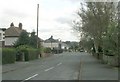
1
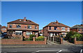
Houses on Whitehall Road East (A58), Birkenshaw
Image: © JThomas
Taken: 27 Feb 2020
0.01 miles
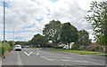
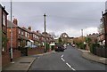
3
Whitehall Road East (A58), Birkenshaw
Towards Drighlington.
Image: © JThomas
Taken: 27 Feb 2020
0.02 miles
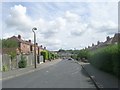
5
Ghyllroyd Drive - Whitehall Road East
Image: © Betty Longbottom
Taken: 31 Oct 2008
0.04 miles
6
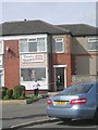
Derek's Mens Hairdressers - Old Lane
Image: © Betty Longbottom
Taken: 17 Aug 2011
0.04 miles
7
Whitehall Grove - Whitehall Road East
Image: © Betty Longbottom
Taken: 31 Oct 2008
0.04 miles
8
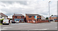
Convenience store, Whitehall Road (A58), Birkenshaw
Image: © habiloid
Taken: 11 Jul 2020
0.06 miles
10
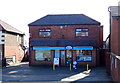
Post Office and shop on Whitehall Road East (A58), Birkenshaw
Image: © JThomas
Taken: 27 Feb 2020
0.06 miles